INavX: Marine Navigation Customer Service

- CompanyNavX Studios LLC
- CategoryNavigation
- Published2019-02-12
- Current Version5.6.32
- PriceFree
- Content Rating4+
- CompatibilityMin. IOS 13.0

- INavX: Marine Navigation Customer Service
- INavX: Marine Navigation App Comments & Reviews (2024)
- INavX: Marine Navigation iPhone Images
- INavX: Marine Navigation iPad Images
Marine navigation is made easy with iNavX - the world's #1 handheld Chartplotter. Access marine charts, maps, weather, AIS and more!
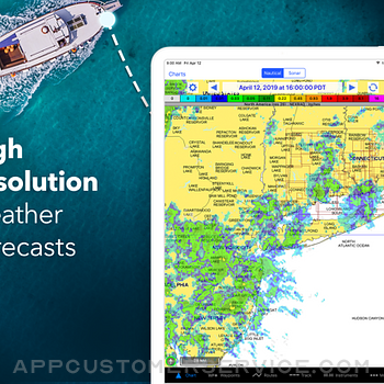
iNavX is the only app to give you complete worldwide chart coverage, from all your favorite charts providers, including the ALL NEW iNavX Professional+ Chart series! Fully enabled with one-touch access, iNavX gives users access to the broadest set of marine charts and maps from multiple providers including:
• iNavX Professional+ Charts
• Blue Latitude
• CHS
• Explorer
• Theyr Weather
• Waterway Guide
• … and more
How does iNavX take handheld marine navigation to the next level?
• Sailors - Plan sailing routes with waypoint and route management. Get proactive sail management with GRIB weather forecasts and then keep watch with AIS overlays and integration with your onboard systems. Plus, you can remember your great sailing locations by geotagging photos.
• Boaters - Stay up to date on boating conditions with forecasts that include currents, winds, and swells. Manage your boating equipment with nautical instrument integration and then save great boating routes to share with the track log.
• Anglers - Discover new fishing spots by scouting out holes and inlets. Locate the best fishing conditions by identifying cold fronts and save your best fishing spots with unlimited markers.
Advanced features - iNavX is the most feature rich app available for all sailing and boating needs at a great price:
Advanced Chart Plotter
• Plot your position in real-time using your device's built-in GPS
• Pan, zoom, and rotate charts (including course up)
• Print detailed charts to use in combination with the app
Advanced Navigation
• Create waypoints and plan routes to navigate between them
• Track log allows you to record your route
• Import/export data in KML (Google Earth) or GPX format
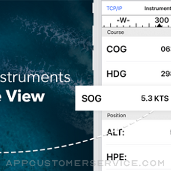
Advanced Instrumentation
• Supports NMEA data over TCP/IP (using Wifi)
• Integrates with external GPS, AIS receivers & transponders
• Connect nautical instruments: Depth, Speed, Wind, Engine, Batteries, etc.
Essential Toolkit
• GRIB weather forecast
• Tides/currents
• Anchor alarm
• AIS integration
• Port/navaid search
Download iNavX TODAY and automatically receive a complimentary copy of the official and up-to-date high-resolution NOAA RNC United States marine raster charts.
REVIEWS
“iNavX is the original and still one of the best navigation apps.”
– Practical Sailor
“The most full-featured navigation app around and viewed by many as the standard”
– Sail Magazine
"The #1 recommended marine charting app"
- iMarineApps
iNavX is Compatible with: Theyr Weather, Waterway Guide, AIS, Brookhouse, DigitalYacht, ShipModul, vYacht, Vesper Marine, NMEA 2000, Chetco and more.
NEW CHART STORE
Purchase all your favorite charts. Chart subscriptions vary by chart and provider from $9.99 to $199.99 annually, charged to your iTunes Account, which will automatically renew unless cancelled at least 24 hours before the end of the current period. Auto-renew can be turned off anytime by going to your Account Settings in iTunes after purchase. No cancellation of the current subscription is allowed during active subscription period.
NOTE: Continued use of GPS running in the background can dramatically decrease battery life.
MORE INFO
Website: http://inavx.com/
User's Guide: http://inavx.com/help/
Terms of Use: http://inavx.com/terms
Privacy Policy: http://inavx.com/privacy
INavX: Marine Navigation App Comments & Reviews
INavX: Marine Navigation Positive Reviews
Is it worth it?Everywhere you look you would think you can use Navionics Maps - nope, no longer available. Oh, how about C-Maps? These are even listed on recent advertisements - Nope, no longer available. But, you can purchase the INavX maps subscription for $60, in addition to the cost of the app. Or, you could go straight to Navionics and use their maps for $20 with their free app, or go to C-Maps and use their maps for $15 with their free app. Oh, but INavX does let you use the old NOAA raster maps for free, but then so does pretty much every other free app out there. Might be a good app - don’t know, not going to pay 3 to 4 times more for their maps than the extremely highly rated and industry standard Navionics or C-Maps. Knowing this in advance I would have never purchased this app..Version: 5.6.6
Exceptional!I really cannot understand the recent (and few) negative reviews... I am slipped in the Santa Cruz, California small craft harbor. I have 20 year old integrated Raytheon electronics (fish finder, radar, chart plotter) and following the tsunami that hit our harbor, I lost the chart plotter functionality. Knowing that to replace my integrated system would cost me over 10K, I 'rolled the dice' and downloaded INavX to 'temporarily' replace the plotter as I was not prepared to haul out, $$$, etc. Well, over two years later I still am not planning a haul out for electronics as... I now am very satisfied with my IPAD/INavX next to my radar and fish finder. I currently have all my fishing and important navigation coordinates loaded and adding new ones regularly with a tap of the stylus. In actuality, don't even miss my old chart plotter... Thank you INavX... Captain Rich Bonny-Matit.Version: 5.5.5
Circumnavigated in 2 yrsFound iNavX to be very reliable and accurate everywhere we went, French Polynesia to N Australia, Indonesia to India, Red Sea through Mediterranean, Cape Verde to the South American Giuanas, Southern Caribbean to Panama, now up the Central American & Mexican Pacific coast. I highly recommend it as a compliment to a chart plotter. Charts for our B&G chart plotter are expensive so I don’t buy them and just use the generic world chart that comes free with the chart plotter. I subscribe to the iNavX Navionics charts per region as needed, and then plan my routes on iNavX, with all its visible detail, and transfer the waypoints to my chart plotter. I use iPhone 6 Plus but maybe a tablet, with its larger screen, would be better. Be great if someday PredictWind GPX’s could somehow be imported and managed..Version: 5.5.4
Good App, but...We have used this app for two years now, sailing out of St. Augustine, FL, and now bound around the world on our 35' sailboat. This app has many nice features and it has gotten us through the Caribbean, now 3,000 miles. I really like the way it works and the detail it shows. I prefer the Navionics charts. We run the app on our iPad2 as our primary chart plotter, and keep a back-up iPad2 loaded with the same charts. You are allowed to run charts on two devices for the one purchase price for each set of charts. Here's the "But...": This app does not support Active Captain. Active Captain is like TripAdvisor for cruisers. On chart plotters and apps that show AC, you can see details about ports, marinas, and anchorages right on your chart, complete with member reviews. If iNavX allowed Active Captain to show on its charts, it would be about perfect for navigation. Until iNavX supports AC, I will rate this a 4..Version: 5.1.1
Great nav programWe have used various versions of iNavX since it was launched many years ago. We used an early version while sailing in our home waters of Alaska. We used it down through Canada and into Mexico. We used it across the Pacific to Fiji and back to French Polynesia. We think that it's easy to use and stitches charts seamlessly. No nav program is any better than the charts for your area. Mexico has terrible charts, US and Canada have great charts, and many South Pacific countries have so-so charts. If your cruising area is well charted then iNavX will provide excellent navigation. Many of its features are better than our dedicated plotter's so it's worth owning and using..Version: 5.5.10
Great system.My integrated Pathfinder system is 20 years old, and the chart plotter is out of date. It works, but the chart plotter map is old, and updates are costly if you can find one. I tried this with an iPad as an alternative. It was confusing at first, so I read the instructions (duh). This is a really good low cost alternative that is effective, current, and does what I need. I still use the radar and depth finder on the old system. If you have trouble figuring out how to use it, remember the old adage, “When all else fails, follow the instructions.” They are clear and concise..Version: 5.5.10
William JenningsAbsolutely Love it , bought it for $60 back in 2010 , a friend of mine bought a 32’ shrimp boat in Louisiana & it only had a cheap vhf radio on board & no other electronics , so I used my iPhone 4 & this app brought us home to Alabama.. I love that it’s entirely GPS BASED !!! No phone service necessary.. it works 100+ miles offshore... Truly Awesome Product ... charts are accurate!!! I will be upgrading to AIS live , in the near future.. it worked flawlessly on my iPhone 6S plus & now iPhone 8+ as well.. Thank You , for creating an awesome Product.. I’m a commercial fisherman.Version: 5.5.6
I don’t get it 🤷♂️For me, electronic maps need to be iPhone/iPad friendly. I don’t need a duplication of paper maps. I need navigation aides and directions, etc. I don’t think this app hits any markers Inhave🤷♂️ it is just paper maps on the iPhone. Either I am too stupid to figure out how to use it or it is in-intuitive. To be real, what I want on my electronic device is a maritime version of google maps. Ie: 1- download app, need some maps. Okay, select charts, west coast, entire west coast. Select download, part way through informed that one of the maps is no longer available- process stops. Okay, download individual maps, ouch - that is painful. This process is untenable!!! 2- Zooming out requires you to name the map you want to zoom out too- Ug! I am definitely not the target audience. I have a book and a chart folder for my charts. I am looking for the next level of navigation not ancient mariners charts. If someone wanted to convince me otherwise I would love to see why this app is otherwise useful..Version: 5.6.22
Accurate Precise works with GPS, but not sure of reliabilityFor $4.99 I should not complain. But, no Track Up???I mean, c'mon, how difficult is that to implement? Also I lose the chart sometimes and have to redownload. I fear that will happen on the fly when I meed the chart and do not have internet access on the water. So the $4.99 is a waste if I can't rely on it. For now though, it's worked well for coastal and bay cruising to keep me safe from shallows and obstructions. Really dislike North Up only, but I can live with that and hoping they'll come to their senses with a fix..Version: 5.5.6
Best app purchase ever!!!I have had this app for over 5 years, and I have received immense value from the purchase. While it is always best to confirm location with other means, iNav has never failed me. Being able to have redundancy, on both my iPad and iPhone, allows for extra piece of mind. Updating charts is easy. I have traveled extended trips in the Great Lakes and connecting river, including anchoring out using the anchor alarm feature. This app will be a necessity in an upcoming Great Loop trip..Version: 5.1.1
Recommended by my sailing instructorThis app was initially recommended to me by my first sailing instructor. I cruise often now and bought many other marine nav apps but keep finding myself using iNavX. This app has all the features of my on board chart plotter and is more intuitive in my opinion. Thank you for keeping me safe over many years and creating beautiful memories. If you sail, do yourself a favor and incorporate this app into your regular equipment rotation..Version: 5.0.9
ReviewHi I believe if you can use your iPhone or device with this program you can get anywhere like a map, lol well it is a giant water map with detailed information or pictures to adjust where you may be or need to go to. The next program that would be amazing would be a program that can be used without internet, WiFi, or anything that needs satellite interactions. Hope this helps you, much Aloha. Nicho.:).Version: 5.5.4
Use this app often if you work at sea.This app was initially recommended to me by my first sailing instructor. I cruise often now and bought many other marine nav apps but keep finding myself using iNavX. This app has all the features of my on board chart plotter and is more intuitive in my opinion. Thank you for keeping me safe and creating beautiful memories. If you sail, do yourself a favor and incorporate this app into your regular equipment rotation..Version: 5.2
Easy and Simple!I took my small craft out on the South Channel of the Straits of Mackinac for the first time last week. I was able to plot waypoints and get a heading within minutes. Our party traveled to Mackinac Island, Cheboygan and Bois Blanc Islands all week without a hiccup. We even navigated safely back to our port after the fireworks in a near moonless evening. Best $4.99 I've ever spent! This app, coupled with a handheld marine transceiver allowed me to boat in the Great Lakes with a 19' bow rider!.Version: 5.5.6
Very SatisfiedWe have been using iNavx for years. From the start, found it extremely easy to use and equally helpful. Customized instrument settings provide the info you want balanced w readability and font size. Loaded on both iPad and phone (at Nav station and on deck). It is very simple to touch and drop a WP and to see location on chart; range; bearing; SOG; COG; VMG. Great tool and very intuitive from the start..Version: 5.1.1
Overall Pretty ReliableI will never buy another marine navigation app. iNavX has proven to be just as accurate as any instruments we have in the wheel house while offshore so I would recommend it to anyone who works offshore. My only complaint is when you rotate your iPad to landscape mode, the heading of your ship is being shown 90° to Port. That is beyond annoying. If that were fixed, iNavX earns an easy 5 stars..Version: 5.6.11
INavX AIS LIVEBad app does not gives what it offers “World wide” coverage and that is plain false and the fact that it requires WFi or good Internet connection makes it useless for real ocean sailing, so it is too expensive for “no service” ( there is no way to get your money back even if you unsubscribe just 4 days after getting it) Xavier González Ortega.Version: 5.5.6
How do I get my Navionics charts back?I bought a new iPad for an update. All my charts got transferred except the Navionics charts. I’ve contacted the developer more than a week ago and yet to hear from them. So, how do I get my Navionics charts back? Please let me know how to do this soon. I go back to Panama in a month where the WiFi is slow and data transfer difficult..Version: 5.5.6
Charts are not linkedI find that having to load and switch back and forth from chart to chart is not seemless enough. I used "Charts" app on the iPhone 5 but had to go with a new app with the iPhone 7 IOS 11. I recently went to the Bahamas and there were no NOA Charts of any detailed scale. I'll continue to try this out for around the chesapeake bay as it looks like it will work OK for that even thought I have to constantaly change charts manually from one scale to the next..Version: 5.1.1
Powerful app, but the mapsI was using the app with the noaa data for many years. very clunky with zoom in and out. Bought the USA maps upgrade and wow! Just got two more stars. Works like it should. App is complicated, lots of stuff, but way easier to use than handheld gps devices..Version: 5.6.16
Stagnated. And push advertisingNot a lot of new features over the years but a lot of advertising. Also, when an advertisement says "x % off ALL CHARTS" it should mean all charts. But the promos never work on Canadian charts and the support persons never address the issues. Happens once I understand but this is a constant pattern..Version: 5.5.6
Very good navigation toolWe forgot our Garmin Marine GPS for a trip in Prince William Sound. Downloaded the application into our iPhones & were very happy with the results. Even with one bar in spots of the Sound the results were quite accurate. Some of the icons like rock hazards * were too large for necessary routes into meandering passages but eyes on the bow & a depth sounder made it a very useful tool. Speed over ground seemed spot on..Version: 5.5.6
5 stars!!!Large set of maps for reasonable extra cost (at least as far as marine charts go). The interface and settings options make this app or choice for true navigation. And finally: you can plan your route at home, enter all the waypoints and then have everything handy at sea. Five stars well deserved..Version: 5.2
The best chart plotter on the marketINavX is the best chart plotter available. I’ve used it for years now and have it with me every time I step aboard. It’s mobile, it’s digital, it’s in my pocket all times. Most importantly it is easy to use, has all the charts I need for all over the world, and really handy features like weather and AIS..Version: 5.5.6
Off line use, iPod, bad elf for gpsThe good: Very minimal investment for a functional chart plotter. Ability to add photos to waypoint. The not so good: Can’t knit charts. Can’t change route headings to magnetic. Can’t change weight of track lines. Chart inserts don’t download with chart. Too many non-nautical icons and not enough charting icons. Can’t add notes to routes. All-in-all a very useful app..Version: 5.5.10
Buggy update—BEWARE!Ordinarily, this is the best marine nav app available (tho I’ve been asking for features in this latest update since the app was first released in the dark ages). Unfortunately, these long-overdue changes killed my ability to see my $90 Navionics charts (for which I was charged full price instead of the usual renewal price—but that’s another story). DO NOT UPDATE UNTIL THEY FIX THIS!.Version: 5.5.2
Great, but flawedThis is a great app for the price. However, managing Chart downloads is extremely inefficient and time consuming. They should give you the option to download only specific regions (i.e. New England, or Florida) and not a whole coasts. They should also allow you to batch delete charts and not have to delete them individually, each with the multiple menu selections just to remove one chart at a time..Version: 5.0.9
" Good app, very stable - User friendly, no-nonsense. "Stable app. Easy and fast plotting and planning, correcting on the fly, panning and zooming. All you need and more for a fraction of the price of a RayMarine. Add a water tight housing (beware for direct sunlight exposure and subsequent overheating!), and you have your chart plotter at hand in every weather condition. I wouldn't want anything else..Version: 5.2
Fantastic app for all sailorsI just spent 2 weeks sailing running iNavX. Fantastic apps amazingly easy to use, very comprehensive in planning route, waypoints... very good maps easy to buy ... I have a lot of experience with PC based navigation software, iNavX brings the power of all these applications right at your fingertips ....Version: 5.2
The One to HaveWe have used INavX for 10,000 nm of travel, mostly on the ICW and adjacent waters. Because it used NOAA charts, it works well in part because we always have a paper chart handy just in case. At first, our blue water sailing friend was skeptical, but after two days he agreed that with INavX and an IPad, there is no need for a chart plotter..Version: 5.2
Good but not intuitiveI like the reference to original charts, but I find the interface to be a bit clunky moving between charts and zooming. On the other hand, it’s pretty obvious where the information is coming from compared to some of the other charting apps. This is a good app to have in conjunction to one of the other vector-based charting apps..Version: 5.5.5
Great App!Really appreciate being able to navigate and confirm my location using this app and my phone or iPad. Makes my travels much safer and efficient. Could be a little better, the pointing of the vessel, it often it shows me aimed in a different direction than I am, however i just use the corse line to make sure it’s aimed where I want to go..Version: 5.2
Great AppFairly easy to use! I have been using a Furuno chart plotter which is a bear to operate. More time to figure out than time of actual navigation. I like the idea that I can down load and update any chart anytime anywhere. NOAA charts are free! Some of the procedures aren't as intuitive as I would like. I'm of an age where my memory isn't quite so good so would like to see a simple easy to use set of basic instructions. As it is an app on installed on my iPad It reduces the need for a standalone chart plotter and other computer gadgets greatly reducing onboard clutter and frustration. Overall, a great app at a fair price. Customer service is great too!.Version: 5.0.9
Good: hi-rez maps. Bad: user interfaceI like how I can download free hi-rez maps without a subscription. What I can’t deal with is the user interface. It’s difficult to download maps, switch between maps, and I don’t know why the + and - symbols on a map attempt to do things other than zoom in/out, which is pretty much a standard convention for map apps. I prefer the UI of Navionics app. It’s way more intuitive..Version: 5.5.6
Great IPad Navigation App!INavX takes a little time and effort to learn all its functions and offerings, but it is well worth it. INavX support is exceptional. Being able to overlay AIS, weather, and Waterway Guide Explorer, makes it even more valuable on the water. My only negative comment, is that the Canadian CHS charts are no longer available, no fault of INavX. Waterway Explorer refers to the CHS Charts, so it is a lose. However, I understand INavX is working to find another source. A 5 Star app, in my books!.Version: 5.5.4
Best and easiest navigation app.Waypoints easy to input. Maps are available..Version: 5.5.6
Great Nav appI’ve been using iNavX (or it’s predecessor) for years. It’s solid and dependable. Never any problems. If you are iOS, don’t hesitate. If you want a professional, easy to use nav app: Just get it..Version: 5.6.16
No charts of Canadian west coastNot what’s advertised in description Big disappointment Big waste of money.Version: 5.5.9
InvaluableI didn’t find the app immediately intuitive; however, watching a couple of easily accessible YouTube videos was all it took. Navigated a 5 day and a 10 day sailing trips on Lake Ontario over the summer using only iNavX on my iPhone..Version: 5.6.3
Clunky U/ISpin wheels are frustrating to use for inputting latitude and longitude for waypoints. Why can’t this be done using a number pad?.Version: 5.5.10
AwesomeWorks well for Me.Version: 5.5.8
Good appAnother update to say thanks for the great customer service. I was hesitating about paying for a second subscription for my phone, but this is a company that deserves my support - they'll get a bit of bonus revenue from me this year..Version: 5.5.6
Amazing chart selection, great supportThe chart selection is amazing. I had a small issue with charts not showing up. I received very responsive support. My problem was resolved promptly. Well worth the buy..Version: 5.5.2
VIews of a novice electronic chart userIt took me a while to get my head around how the program works but I am at the point where I can complete a journey, make changes to my route and have the security of knowing where I'm located at all times. I would recommend this program to anyone who wants to sail safely..Version: 5.0.9
QuiltingBought charts for Croatia. Trying to prep route at home before going but can’t seem to go seamlessly from one chart to another. There must be a way..Version: 5.2
What is this alarm aboutXxxxxxxxx.Version: 5.5.6
Chartplotter liteI like this app. It can download raster charts, look at them and get a familear course and velocity indicator. The iPhone gps is not as responsive as a Garmin or raytheon for getting accurate speed and course so I doubt that it will be useful for sailing. Perhaps Powerboating though. I'd prefer to use ENC charts than Raster. Perhaps later..Version: 0
Superb App...I have read with interest some of the comments about having to download the costly Canadian Charts. That isn't a problem with X-Traverse or INavx but with the Canadian Government charging for this service. Note that the NOAA Charts for the US are free, by comparison. You can always download the Navionics charts for Canadian regions instead that are cheaper. This is an unbelievable app. I have the Navionics and CHS charts for the waters inside Vancouver Island and with these charts, INavX is superb. It outperformed the chart plotter on the boat we chartered by a country mile and it had all of the capability of that we needed. Apparently it can be used with Auto pilot systems through NMEA but I cannot comment on that. Jim.Version: 3.5.6
BCImpressive but expensive. Navionics at $9.99 is just as good.Version: 0
Amazing!This application is absolutely amazing. I purchased it when it was originally launched and have used it over and over ever since. To take full advantage, you'll want to have an X-Traverse account ($10/year) as well as purchased digital charts (ex. CHS) and if you own a Mac, GPSNavX. This application and GPSNavX allow your maps to seamlessly sync between your computer and iPhone - including Waypoints, Tracks/Routes, etc. I use CHS Charts on a daily basis with this app and they are fantastic! Ever enter an unknown water area and you're unsure about depth levels? No problem, just pop open the app and using the device's built in GPS (no cell signal required) it pulls open the map that relates to your current position and tracks you as you go along, so you can safely see where you're going. A fantastic app, and kudos to the GPSNavX team for another GREAT product!.Version: 0
Great AppBought this App a year ago and have used it every time we have gone out on the boat. We are on the Rideau system and the maps are great. One evening it got dark earlier than I expected and used it to get back. It is accurate to within 1 meter of the channel markers and got us back safe. Somebody complained about the price on charts, checked Fisheries and paper maps for the entire Rideau is 56.00. A one year license with all the updates is 70.00. don't think it is overpriced and is very user friendly and you only pay for maps you actually want and can use. I recommend this app for everyone that has a boat and doesn't want or need to invest in a chart plotter. I am glad I have this App. Keep up the good work!.Version: 3.2.4
Slick AppThis app works great. Formatted perfect for the iPad. Not sure why people are complaining. NOAA has plenty of free map downloads of the Great Lakes. If you need any more details buy the CHS charts... The app can replace any garmin handheld unit!.Version: 3.2.4
$50 large screen chart plotter in your cockpitThis app is unbelievably great! Canadian Hydrographic Service electronic charts are not free and iNavX can't, won't and shouldn't be asked to eat that cost for you. They are up-front about the price of Canadian waters charts. If you don't want to pay for your region then take it up with CHS but iNavX does not deserve a poor rating because a government agency has a policy you don't like. In a recent three-day race around Lake Ontario. I was able to view 8 km spacing GRIB (wind prediction) data atop my real-time position and track (on iPad). Having it on the large touch-screen makes it immersive. On another boat, I have wired up the instrument package to broadcast over WiFi (using a product recommended in iNavX's documentation). Real-time wind and boat speed and direction and depth can all be shown on-screen along with clear instructions for steering to a waypoint. If there is a danger, it is that you'll find yourself relying on it so much you'll forget to look in front of you! I think most of the negative reviews were because it doesn't make coffee..Version: 3.6.0
GoodINavX, it s a good application but they are only charts for USA because NOAA/Maptech give maptech charts and Encs. I would like put my nauticals charts. If MacENC can send the charts for iNavX it s very good. For this time i paid 50 dollars and i can not use. Like the oziexplorer app can send to ozi pocket th charts. I do not want a server to dl my charts i want put my charts i have already scanned... I don t want pay more..... I want read grib file for see the meteo.......Version: 0
Excellent navigation programVery, very useful and reliable navigation program. I took 1 star off only because I found importing waypoints and routes to be somewhat cumbersome - but that may be due to my lack of knowledge on how to do those tasks more efficiently. This app also works very well in conjunction with their desktop navigation program GPSNavX. Tech support is very fast and helpful; I had a very good response to a query within 12 hours of making the request. I will never leave the dock without it!.Version: 5.0.8
FrustratingEach time I have downloaded an update recently it has deleted my charts. I am cruising and downloading them again costs me time and money. I love the program, but one day the charts aren't going to be there when need them..Version: 5.0.7
Free International Money Transfer 💸Enjoy high maximum transfers into more than 20 currencies while saving up to 90% over local banks! The cheap, fast way to send money abroad. Free transfer up to 500 USD!Version: 5.6.32
What do you think INavX: Marine Navigation ios app? Can you share your thoughts and app experiences with other peoples?
Please wait! Facebook comments loading...