EasyTrails GPS Customer Service

- CompanyZirak S.r.l.
- CategorySports
- Published2009-08-14
- Current Version11.4
- Price$3.99
- Content Rating4+
- CompatibilityMin. IOS 11.0

- EasyTrails GPS Customer Service
- EasyTrails GPS App Comments & Reviews (2024)
- EasyTrails GPS iPhone Images
- EasyTrails GPS iPad Images
EasyTrails GPS is the GPS tracker application for your iPhone.
The perfect application for those who are passionate about OUTDOOR ACTIVITIES and TRAVELING, everybody who likes outdoor sports, and not only.
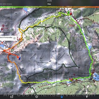
Are you going for a bike or motorcycle ride? Well, EasyTrails GPS will tell you how many miles you traveled, how much time you spent, how high you climbed and many other details. In real-time it will show you the course on a map, comparing it with downloaded tracks and points of interest.
You can import or share all tracks and waypoints, photos and ideas for new journeys with your friends.
Share where you are on Facebook and Twitter through your GPS position, and export your tracks in standard formats, so you can review them on Google Earth, SportTracks and TrailsRunner. Or simply upload them to online services like Garmin Connect, or many others.
It's possible to import tracks by e-mail or Safari (EasyTrails can handle GPX, KML/KMZ and ZIP file formats), or by wi-fi networks, using an improved and easy to use web-based sharing feature.
Calculate routes and let EasyTrails guide you using the new navigation capabilities. You can also let it guide you through previously recorded tracks.
Additionally, EasyTrails GPS can communicate with navigators like Maps, Google Maps, TomTom or Waze (if installed) for more advanced guidance needs.
Load custom cartography, EasyTrails supports KMZ and MBTILES formats.
EasyTrails GPS is easy to use and extremaly accurate. It ensures the maximum duration of battery thanks to the possibility of recording in "StandBy" mode. However, be aware that use of GPS, even in background, will have a significant impact on battery duration.
► For more info, visit our website: www.easytrailsgps.com
NEW FEATURES:
► Heart rate monitoring (paid)
We added the ability to connect to compatible Bluetooth heart rate monitors (such as Polar H6 and H7 devices). Heart rate can be seen in real time from the dashboard.
With the 'Heart rate monitoring' in-app purchase:
- heart rate data will be associated to GPS tracks
- saved tracks will have an extra heart rate chart
- heart rate data will be saved to HealthKit
Additionally, with the 'Colored tracks' in-app purchase, it will be possible to highlight heart rate data directly on the map screen of a recorded track.
OTHER FEATURES:
- Support for many different map types
- Support for different coordinate systems
- Support for user-loaded offline cartography (KMZ and MBTILES)
- Export tracks (single or multiple) in standard formats (GPX, KML/KMZ and CSV), with their associated waypoints and pictures
- Import tracks (GPX and KML/KMZ)
- Import waypoints (GPX and KML/KMZ)
- Resume recording of tracks
- Save waypoints with photos and descriptions
- Navigate to a point of interest
- Sharing via Facebook and Twitter
- Follow a path/track
- Navigate (distance / direction) towards any waypoint
- Navigate (distance / direction) towards any track marker (start / pause / resume / end points)
- Advanced Navigation to a waypoint using any navigation app you may have installed
- Upload tracks to GPSies (http://www.gpsies.com)
- Upload tracks to SportTracks (http://sporttracks.mobi)
- Upload tracks to OpenTrail (http://www.opentrail.us)
- Upload tracks to OkMap (http://www.okmap.org)
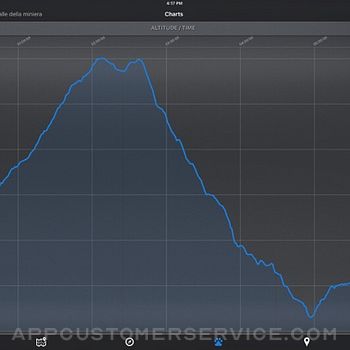
- Real-time visualization of distance, speed, altitude bearing and other data
- Map Visualization in different modes: street map, satellite, hybrid, terrain
- Charts (elevation profiles, ...)
- Digital Compass
- Heart rate monitoring
- Turn by turn directions
- High battery duration (record in standby)
- Select between metric, imperial and nautical measuring systems
- Intuitive and User Friendly interface
- Lightweight, reliable and accurate
- Doesn't require internet connection
Terms of Use: https://www.apple.com/legal/internet-services/itunes/dev/stdeula/
Privacy Policy: http://www.easytrailsgps.com/wp-content/uploads/2016/05/EasyTrails-GPS-Privacy-Policy.pdf
EasyTrails GPS App Comments & Reviews
EasyTrails GPS Positive Reviews
LOVE LOVE LOVE this app!!I ride horses and use it to track my rides. I have truly tested having no cell service and depending on satellite and it continued to track me real time. I even got lost in a national forest and used the map to track back to my original starting point (I use this frequently in forested areas). I am also able to push my racking horse and see out speeds improve with the "maximum speed" tracking. It will also show you local roads that you maybe near should you find yourself in an accident. It does far more than I need it to and everything that I want it to. Well worth the money! I have tried a few others and was disappointed in their performance and that they "lost" me in poor reception areas. With a little bit of photo editing skills and a good program you can even use these tracks to make trail maps for public areas. My only suggestion: if you are horse back riding, strap the phone to YOU not the horse! Every time I show people a track of my rides they want to know "What's that app!?" EasyTrails! Love it!.Version: 9.20
Works Great for Ride TrackingI have used Easy Trails to track my trail riding mileage for several years. It’s simple to use and functions even when I don’t have cell service. It’s also super easy to export tracks to TopTrail. It would be great if I had the ability to edit a track when I occasionally forget to turn it off when I am done riding, but otherwise I love it..Version: 11.3
Very useful for my needsThis app is perfect for GIS grade trail mapping and property reconnaissance. I use the custom coordinate system option to collect data in my local state plane zone. The email export function sends GPX and Google tracks that work seamlessly with my Carlson Survey and ArcMap software. Pretty cool stuff..Version: 9.24
In-app purchase won’t work.I purchased the ability to download maps offline, unfortunately, after trying forever to figure out how to simply get an API key for Google Maps because of poorly written instructions, the app crashes the instant that I try to paste or type the API key. Otherwise, the app is great as long as you have service. I’ve used it for years. It desperately needs an update..Version: 10.5
Lives up to its nameI have several trail apps for tracking Trails from horseback. I always turn to Easy Trails as it is straightforward but has all the features I need..Version: 9.24
Trail dragonI love this app, been using it for years. Wondering if anyone else questions accuracy of the speed part of the app. For myself it is not accurate. Other than that I love it!.Version: 11.2
Great app for hikersI use it to record tracks for hiking trails. Only issue I have had was when iPhone X came out and they fixed that promptly..Version: 9.25
Excellent map app!The big library of overlay maps (Caltopo, nautical, Google, OSM, etc) set this app apart from the rest. Use it all the time!.Version: 9.19
Great AppBeen using this app for years. Very easy to navigate. My go to app.Version: 11.2
Trail riderIt’s great it’s keeps up with the miles I drive my team of mules.Version: 11.2
Great Trail Equine AppThis app has delivered from local trail to the Big South Fork! Thank you! Vicky Rhein.Version: 11.2
Great Mapping AppSuper easy to use!.Version: 10.3
Great, Fun and Easy!Just downloaded this on a whim.... My Garmin bike computer needs a new battery to the tune of $50+ for the service, so thought I'd give this a go. Went on a 22 mile mountain bike ride, and had easy tracker track our ride. It worked great, the only thing I noticed amiss was the assent and decent numbers didn't match, which if you start and end in the same place, of course should match. But overall, the 3 types of maps are quite cool, and shows the locations that we stopped with yellow push pins the overall time as well as the actual time we were moving. The ride was easily exported to email and mailed to a friend....Just not sure how to open a GPX file.....Guess I'll have to figure that out, maybe the developer has some info on that.....HIghly recommend..Version: 4.2
Excellent for Trail Map CreationWonderful app for creating trail maps with points of interest along the trail. You can use the IPhone camera to capture the POI. Very easy to use -- Just start EasyTrails and push the record button. It automatically collects the GPS points and displays the trail as you walk. It works great with the IPAD and the IPhone. In my experience,the GPS sensitivity on the IPAD is much better than my Garmin Etrex that I have used to document trails. I found that you can start EasyTrails recording your trail on the IPAD and then put it in your backpack. It recorded a new 5 mile trail perfectly. It doesn't get any easier! I found the altitude and distance seemed to work fine! You can export the trail via email and share with friends. It also creates a GPX file that can be used with other programs and Google Earth!.Version: 0
Great GPS App!So far this is the best and most reliable outdoor GPS app I have found of iOS. It is perfect for hiking, biking, geocaching, etc. The app is fully featured and tracks all of your movement data, allows waypoint input and tracking, track saving and uploading, as well as stat breakdowns of your tracks. GPS is very accurate, maintains a signal very well in a pants pocket, and doesn't kill battery life. HIGHLY recommend this for anyone looking for a great outdoor GPS app..Version: 8.5
You can switch from metric to imperial and back.I've used this app for about a month and it seems to work fine. You can switch between metric and imperial measurements by going into the settings app on your iPhone. Scroll down to the bottom and you should see a list of apps for which you can change the settings. Go to the EasyTrails tab and you will be able to change the units as well as some other settings..Version: 0
Very nicely written AppWorks exactly as advertised. Maps are accurate and charts are accurate. The settings can easily be changed from metric to imperial (through IPhone settings - the comments on some reviews that it cannot be done is simply wrong). One suggestion: It seems the altitudes are derived from the GPS. I have seen other apps that show altitude based on Map location. It would be useful if one could change the settings to measure altitude based on the Map position..Version: 7.0
Best App That Works Great!!!This app is worth the $$. I don't leave home without it. I use it for hiking, biking, canoeing etc and LOVE it. I love the fact that you can start where you left off. I also love the feature that allows me to take a pic of where I want to go next and then give me directions. I've seen places in route that look cool then take a photo and have directions the next time I want to visit. Awesome. Keep up the good work!.Version: 6.1
Awesome for tracking snow plow routeI love this app. I use it to track my route when I snow plow and it tracks location and times and makes it simple and easy to read. The maps are accurate and easy to read as well. The only thing I wish it had was the ability to add notes at specific points in my route..Version: 9.13
Show off your tracksWhat makes this app different from most of the others is the sharing feature that lets you transfer tracks in and out. You can transfer to your PC in 3 formats. You can transfer old gpx tracks to the iPod and show them on the map, Very slick..Version: 0
Easy, life-saverMakes bikeriding just that much more fun, keeps track of where you go with phenomenal precision, I put it on a holder on my handlebars and it works as an interactive GPS, not to mention after the ride I get a details analysis of my ride including all sorts of charts and data, well worth the money if you are an avid biker!.Version: 6.3
Their support is amazing.We've all seen it: the 'Contact Us' or 'Feedback' or 'We Love Suggestions' button. If we're really passionate, we tap it and spend 10 minutes crafting the letter we're *sure* will get noticed. We tap 'Send'. A few seconds pass and a clearly automated message thanks us for our feedback, and we never hear from them again. Then we stop using the app. Not this time. I requested a feature, and not only did they reply with a thorough explanation, but they've continued to send me updates as they address new features and behaviors that came up in the resultant conversation..Version: 6.1
WOW... waypoints and long battery durationWith the waypoints I think that EasyTrails GPS is really the best app for outdoor tracking. I use in several ways, and it's simply amazing! Then I've seen also that they support environmental projects with the revenues, a good point to support them!.Version: 0
Truly AmazingI have tried few GPS tracking applications before and all those were either slow to pickup GPS signal or consumes more power. But this one is great. Export options are incredible. However i noticed the altitude is not accurate, shows increase in altitude even on a flat surface..Version: 0
BugsApp nagged me to write a review so here it is. Offline maps are great (but additional cost) but this app has a number of bugs. For example it keeps on announcing it is following a route and does this long after I finish a route and I've killed the app. I don't know how to remove from memory. I'll try a hard reset. Anyway the app is mostly good but has some annoying bugs..Version: 9.17
Great appI have used it mostly to mark trails I have been creating on my property and it works great! Have also used it when flying and works great then too! Would definitely recommend paying for the full version if you need it.Version: 9.11
Trail RidingMy wife and I go trail riding on our horses on the weekends, this is the greatest app for that! Not only can you track the trail you can also take pictures on the way and you can share it with your friends through many different apps!.Version: 9.12
Great app!Excellent app. Very accurate tracking. Easy to use. Please join me in spreading the word about the biggest cheating app in the app store. A pool game called Micropool by Botond. Horrible game. Please read the reviews if you don't believe me. Please help by telling everyone you know about this atrocity. Thank you..Version: 4.2
User FriendlyI'm pretty good at learning by using and this app makes using without training easy. While they could have additional information available, this app is great for recording trail rides..Version: 9.12
Very accurate!I use this app for all my hiking and biking and it has always worked great. It also quickly connects with satillites when first turned on..Version: 5.0
Great app-almost perfectI love this app and would rate it perfect except for lacking a default when trying to save a track. It's inadvertently failed to save a track. I use a Garmin GPS as a back-up just for the few times tracks either got stopped or failed to save..Version: 9.12
AwesomeI don't really use all the features because I am not a hiker but it is really cool to have. Totally worth the money if you would actually use it for hiking.Version: 0
Easy trailsI really like this ap! It was a bit slow for me on loading, but it seems to have it all. I will never be lost again. Close trips work as well as long trips. I can't wait to try it while camping in the Ozark mountains!.Version: 0
Battery hogThis app shows promise but it's a huge battery hog. Even a modest 2-3 hr hike will kill the iphone battery. Big problem when you're in the field with no access to power. Also would be useful if it could pull up existing trail maps from the vicinity and overlay them with the live route map..Version: 9.4
Pretty GoodI've tried a lot of these and I like this one the best! the dashboard and compass are great when your out somewhere you've never been and uploading trips to friends is cool. worth the price, and looking fwd to updates..Version: 0
Great app. Now need HealthKit integration.Great last update. I am loyal user and have been using this for years for hunting and cycling. I would love some sort of HealthKit integration so I can import cycling data or something..Version: 8.8
Simply GreatLove the simplicity, the graphs, and maps. Will definitely be using this as my new GPS device on our hiking and biking. Great work and design..Version: 0
Very helpful.I used this app the other day to track a path I had found near my house. Instead of getting lost, I was able to retrace my steps and get home safely. Amazing app and very nice to have!.Version: 0
This is great!This app is something everyone could use! I love everything about it! Thanks :-).Version: 0
Very coolThis app is actually pretty cool. I tried it for mapping a 2 mile course around my neigborhood. since the same route gets boring I'll probably use this app all the time..Version: 0
Great app! Wish it could save maps for longerThis app is amazing for dirtbiking and mountain biking, never get lost again and my battery usually stays pretty full. Wish it would hold on to maps better, usually have to put my phone in airplane mode or it will update mid ride and blank out the screen, that didn’t used to happen. Otherwise awesome app!.Version: 11.2
Dover Street BoyWe use Easy Trails all the time no matter where we go or what we are doing!.Version: 11.0
AwesomeBeen using this app for 3 years now and it works great for fishing and hunting waypoints. Cheap alternative to buying a GPS..Version: 9.24
Love itEasy to use and useful.Version: 9.19
Great, but what about a watch app too?This app is one of my favourites for the iPhone. I use this every time I go hiking, jogging or cycling... but please... PLEASE create an Apple Watch app too. This would make it so much more enjoyable. I would have made this a 5-star rating if I could use this on my watch..Version: 9.20
Just perfect!I bought this app long time ago and I have been amazed in every single update. I just love it. It is simple and gives a huge value. Congrats, I can tell there is a big piece of work behind this..Version: 7.0
Fair appCan replace a pocket GPS unit for a couple of days. Does not hold offline maps more than 3-4days I think. No major bugs to report here. Waypoints and trails work great with Google Earth both upload and download!.Version: 9.19
Easy Trails GPS 5Very happy with this app. It worked up at the top of a mountain and since we got lost for a bit it was nice to look at the map afterwards and see where we went wrong :) also, I still had battery left after it ran for 2 hours!.Version: 5.0
Almost there...If you could import .klm files, this app would be awesome, but right now it just shows you gps point (a single at a time) unless you recorded a track....Version: 6.0
Very satisfiedI purchased this to track my mountain biking and map trails near my house. This app works great and runs in the background. Great app!.Version: 0
Good enoughThis app does its job pretty well, and as long as you don't expect too much it should be plenty. It uses less battery power than the similar MotionX app, and getting tracks from the app to the computer is very easy. My only gripe is that there are no "speed vs. time" plots, when they seem to have everything else covered..Version: 0
Free International Money Transfer 💸Enjoy high maximum transfers into more than 20 currencies while saving up to 90% over local banks! The cheap, fast way to send money abroad. Free transfer up to 500 USD!Version: 11.4
What do you think EasyTrails GPS ios app? Can you share your thoughts and app experiences with other peoples?
Please wait! Facebook comments loading...