Planimeter GPS Area Measure Customer Service

- CompanyVisTech.Projects LLC
- CategoryProductivity
- Published2014-07-23
- Current Version2.1.14
- Price$6.99
- Content Rating4+
- CompatibilityMin. IOS 10.0

- Planimeter GPS Area Measure Customer Service
- Planimeter GPS Area Measure App Comments & Reviews (2024)
- Planimeter GPS Area Measure iPhone Images
- Planimeter GPS Area Measure iPad Images
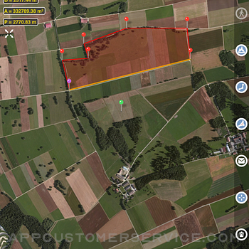
Planimeter is a tool to measure distance, area and perimeter on a map. You can measure manually or by GPS tracking. You can also check the bearing and geo-coordinates of your location and share it. Points can be labeled, saved and shared in KML format.
This measurement app is useful for outdoor activities and can be used as land surveyor by amateurs and professionals in various industries like sport, farming, landscaping, paving and construction, road building and repairing, real estate business, hiking and travel, fencing, lot building and planning, solar panel installation (roof area estimation), object mapping, lawn design, and many other where land area and distance / length calculations, land survey or maps are involved.
If you have any question about Planimeter and its functionality, please check How To Use Quick Guide:
http://ios.vistechprojects.com/Planimeter_iOS_QuickGuide.pdf
Video Demo:
http://youtu.be/unjYbPCIYM0
http://youtu.be/QQMilHVD5e8
Features:
Accurate distance and area calculation
Metric and Imperial units (m, km, feet, yards, miles, ha, acres)
Angle between lines
Bearings To and From the point
Forth and Back navigation through points by touch on Info Panel
GPS coordinates of a point
GPS accuracy settings (if GPS available)
Manage previously saved projects: open, save, share KML files
KML files created by Planimeter can be imported to GEarth and GMaps to view on a desktop
Send data by email: picture, coordinates as text message, KML file
Save KML or TXT in local storage
Map/Satellite View
Zoom and Edit points
Current location search
Text (address) search
Delete selected/last/all points
Zoom to Fit-in and center points on a screen - quick points search
Add points by touch
Add current location as a point
Show location with Latitude and Longitude coordinates
Add points by Geo-coordinates: Lat and Lng
Option to center last point added
Option to show/hide lines
Preferences: location accuracy, tracking time interval, delete points confirmation, sound option for tracking
Separate units settings for distance, area, perimeter
Target Mode for accurate pin placement
Show current coordinates in Target Mode
Stylus Draw Mode
Full-screen option
GPS TRACKING
Manual pin placement in GPS Tracking
The app has been successfully used in different areas:
- outdoor activities: sports, golf (distance between two points or holes), bike tours, trail planning, travelling, quick path measure
- garden and yard: landscape planning, grass cutting, lawn care and mowing, fencing, grass seeding.
- agriculture, poultry and farming: harvesting, fertilizing, crops (corn, wheat, maize, beet, etc.) planning and estimation, field area measure, paddocks and area fencing for cows, horses, chickens, rabbits, etc.
- solar energy: area estimation for solar panels, flat roof area estimation
- construction: land survey, road sealing, parking lot repairing
- forestry: objects and tree mapping, damage area estimation, measure land area
- other: ponds size and are measure; pole lines planning; movement tracking; get exact GPS coordinates of way-points; fence calculation; geocaching.
Note: Continued use of GPS running in the background can dramatically decrease battery life.
If you like the app and find it useful please support us with your feedback and comment.
Feel free to contact [email protected] with any questions, comments or bug reports.
Planimeter GPS Area Measure App Comments & Reviews
Planimeter GPS Area Measure Positive Reviews
Great app for asphalt estimation but needs a few improvementsI just used this app to double check my field measurements instead of having to drive 2 hours, and measure in the field for another 2 hours..saving me time and money. 2 things I would to see in the future 1. It would be much easier and more accurate for my line of work if I could zoom in further on the satellite image. It’s fine if it’s pixelated, I just need more accurate points. 2. The pins need to be either translucent or simply small dots. The pins coming off the map effect covers up the image where I need to place my next point in some cases..thus causing loss of accuracy. Hopefully these changes can be made, because at this point I’m still looking for a better app. Thank you.Version: 2.0.3
Great appOverall what I’m looking for. Will work great for my lawn service business. The only option I really would like to see added is an address search function, that would help having to look up a property in another app to find lat & long, then back to this app..Version: 2.0.7
Multiple sectionsI’m currently trying to divide up in thirds (approx 8.3 acres each) 25 acres along a partial of land that is road side on one side and a creek running diagonal across the back. I would like to be able to keep highlighted each 1/3 as I move and adjust the pins so that to keep track of the boundaries and find my layout to make the equal division of land. Makes sense ??.Version: 2.0.8
Good for walking field boundariesI find this app works well in documenting field boundaries for agricultural purposes. It matches my handheld high-precision Garmin unit very well on reasonably clear days and does a faster job of documenting areas via screenshots. I like that it will export the raw data points too. On cloudy days with worse GPS signal, I still need to use the smaller handheld hardware unit..Version: 2.0.7
Best I’ve found but not the best it could be.What this app does is highly valuable. How it does it could be better. I wish it would zoom in more than it does..Version: 2.0.14
Easy to useThe App seems to work great. Easy to use. Some of satellite views make it difficult to see how to measure (not app fault).Version: 2.1.8
Farm boyThe app works great and as accurate as any other I’ve used had this app since it’s beginning and been happy everyone I used it..Version: 2.0.14
Terrific ResourceSo much information—and flexibility—literally at your fingertips. Most highly recommended..Version: 2.1.11
Great for mapping landUsing it to measure and map out spaces where I can grow plants on a property that has trees dividing up the spaces and hilly terrains in certain areas..Version: 2.1.3
Amazing AppI really like it, It is very practical and help me a lot in my job I learn to use it as tool to create Kmz with notes.Version: 2.1.12
Zoom qualityI can’t zoom in far enough to get exact measurements.Version: 2.0.13
Needs work and buggyI see what you’re trying to do, and this could be a handy app. Buggy: I allow location use While Using and it says that I disallowed location. Needs: delete pins, move pins Since I couldn’t move or delete pins, and it doesn’t know where I’m at…. Going to leave it alone. Maybe check in a few times a year to see if it’s any better..Version: 2.1.12
ConvenientEasy and simple way to measure areas..Version: 2.1.12
Not user friendly. How to enter an addressNot user friendly. How to enter an address.Version: 2.0.7
Use it for work; great assetEasy to use and nice to be able to store measurements for reference..Version: 2.0.15
Great for tracking paths through the woodsI use this for tracking my paths through the woods..Version: 2.0.14
Distances and Acreage Seem AccurateIt is a good app to get an idea of walking, hiking, and biking distances before leaving the house..Version: 2.1.11
Seems to be very accurateSeems to be very accurate but takes a little while to learn how to use. Overall like the app.Version: 1.0.20
Land areaBest tool I have ever used to find the amount of area we are flooding for the acreage!!!.Version: 1.0.20
Great ApIt has been very helpful! Satellite images are fantastic!.Version: 2.0.7
Food plotsIt works perfect for what I’m using it for, making food plots for deer!.Version: 1.0.20
Works really wellI provide estimates for asphalt paving. This app is an amazing time saver.Version: 1.0.20
Great other than limited thru isoIt doesn’t show measurements between flags in iso version otherwise a great app for the price.Version: 2.0.13
Best App!Being a Real Estate Broker, Auctioneer and Land Developer; this is the best app I have to use..Version: 2.0.8
😀Pretty awesome! Needs to be more update..Version: 1.0.20
Works.Worth the price..Version: 2.0.14
RetiredThis App works well for determining SF or acreage of a field..Version: 2.1.8
RancherGreat app !! Easy to use.Version: 2.0.14
Turf ManagerAmazing.Version: 1.0.20
UsefulI like the track mode, so i can drive around a field and get the exact measure!.Version: 1.0.0
WARNING!If you purchase this application, beware! This app is functionally OK, but to walk a path to define an area REQUIRES that you leave its location services active, even when not using the phone. You could turn off location services on the phone, but then all other apps using that service, like maps, would be unusable. Unacceptable..Version: 1.0.14
Points by coordinatesGreat app. Only thing missing, is the ability to manually add points by typing in the respective coordinates..Version: 1.0.17
Farm fieldLove the app and helps me to find how many acres I farm but either I can’t figure how or you are not able to mark bush areas in the middle of you field.Version: 2.0.5
Great appVery helpful app for figuring out acres..Version: 2.1.3
Works well and good replacement to old AgriPlotI have used AgriPlot for a while now and it has not been updated in some time, so I have been looking for a replacement. This is a good replacement and the ability to send KML files to Google Earth is a high point for me. One thing that I would like to see is the ability to take a photo at a “point”. Would be good to have this capability included in the notes for a point, track, or polygon so a photo can be referenced for a point..Version: 2.0.5
Free International Money Transfer 💸Enjoy high maximum transfers into more than 20 currencies while saving up to 90% over local banks! The cheap, fast way to send money abroad. Free transfer up to 500 USD!Version: 2.1.14
What do you think Planimeter GPS Area Measure ios app? Can you share your thoughts and app experiences with other peoples?
Please wait! Facebook comments loading...