FATMAP: Ski, Hike & Trail Maps Müşteri Hizmetleri

FATMAP: Ski, Hike & Trail Maps (Strava, Inc.) Uygulaması Hakkında

FATMAP by Strava is the #1 app for mountain sports.

Explore the mountains with confidence with the world's most advanced 3D outdoor map. Plan the perfect route, orientate and navigate along the way, record your day and share it with the community.
Whether hiking, biking, trail running, skiing, ski touring or freeriding, if you love mountain adventures, you'll find your community on FATMAP.

- Global 3D outdoor map with real-time information and offline maps
- Mountain biking, trail running, hiking, resort and backcountry skiing maps
- Stunning satellite terrain imagery, in summer and winter
- Record and re-live all your adventures in 3D
- Advanced terrain analysis tools including slope, elevation, avalanche and more
- Follow people to see their latest adventures

GLOBAL MAP FOR THE OUTDOORS
- Know the area like a local and plan your route in detail with the most advanced 3D outdoor map that helps you intuitively understand the terrain
- Find any outdoor trail: footpaths, hiking trails, singletrack and more
- Discover outdoor points of interest like mountain huts and campsites
- Choose between summer or winter/snow map imagery (where available)

FIND YOUR NEXT MOUNTAIN ADVENTURE
- Search and find the right route for you or be inspired by the community

PLAN & NAVIGATE
- Create and share custom locations / waypoints
- Locate yourself on the map at any time
- Use peak names, roads, footpaths, rivers and heaps of other map data to quickly orientate yourself and navigate to your next objective
- Navigate trails while riding, hiking, running or skiing

UNDERSTAND THE TERRAIN LIKE AN EXPERT
- Understand the terrain like never before to make better decisions with Gradient, Avalanche, Flats, Aspect and more layers.

RE-LIVE YOUR ADVENTURE IN 3D
- Track your adventure in the app or connect with Suunto, Garmin or Strava to see your tracks in 3D
- Share amazing fly-throughs of your adventure


GO FURTHER WITH FATMAP EXPLORE
FATMAP Explore is for everyone who wants more out of their outdoor experiences.

TOPO MAP LAYERS
- Use the Global Topo map or see official topo maps from swisstopo, USGS, IGN, basemap.it and more in 3D

REAL-TIME SNOW CONDITIONS
- See current snow depth, fresh snow, and snow forecast directly on the map.

REAL-TIME RESORT STATUS
- See which lifts and pistes/runs are open or closed in real time. (At supported Ski Resorts)

OFFLINE MAPS
- Download any part of the map and use it without an internet connection.
- Conserve battery by using the app in airplane mode

THE BEST DEALS ON OUTDOOR GEAR
- Explore members receive discounts in major partner brands like Mammut, Salomon, Suunto, Faction Skis and many more.

(Access to FATMAP Explore requires a paid membership.)

- REVIEWS -
“FATMAP has changed the way I see and act in the mountains” - Xavier De Le Rue, The North Face Athlete
“Useful and inspiring (and also looks really really cool.)” - Forbes
"[FATMAP] may be the most ambitious adventure tech to hit the market since sat phones" - Outside Online
“An app that will revolutionise your backcountry freeriding experience” - Red Bull

** For technical support, contact: [email protected]


FATMAP Explore is available as a 12-month subscription. You can subscribe and pay through your iTunes account. Payment will be charged to your iTunes account at confirmation of purchase. Your subscription will automatically renew unless cancelled at least 24 hours before the end of the current period. You may manage your subscriptions and turn off auto-renew after purchase by going to the ‘Manage Subscription’ page in settings. Any unused portion of a free trial period, if offered, will be forfeited if you purchase a subscription, where applicable. The subscription will renew at the same cost."

Terms of Service: https://about.fatmap.com/terms
Privacy Policy: https://about.fatmap.com/privacy

Kategori Navigasyon
Yayın Tarihi 2018-04-22
Son Versiyon 3.26.11
Fiyat Ücretsiz
Yaş Gurubu 4+
Uyumluluk Min. IOS 12.4

FATMAP: Ski, Hike & Trail Maps İletişim Bilgileri

Şirket Adı Strava, Inc.
Şirket Websitesi about.fatmap.com
Şirket E-Posta [email protected]
Şirket Telefon Çok yakında...
Müşteri Hizmetleri about.fatmap.com/account
Sosyal Medya Facebook / Twitter

FATMAP: Ski, Hike & Trail Maps Aplikasyonu Pozitif Yorum ve İncelemeler

Ödeme Ödeme yaptım senelik abonelik aldım fakat abonelik özelliklerini kullanamıyorum Kullanmak istediğimde hala ödeme ekranı geliyor.. acil çözümm. Empires of otomat Version: 3.13.2

Mgrs Mgrs koordinat sistemi getirilirse çok daha faydalı olur. teşekkürler. Cankarr Version: 3.24.20

Kordinat MGRS Türkçe dil desteği ve kordinat sistemi MGRs askeri kordinat desteği gelmesi gerekiyor saygılar TÜRKÇE language support and coordinate system MGRs need military coordinate support regards. Can396418 Version: 3.8.1

Beni takip ediyor Uygulamayı sildim iphone 13 telefondan halen beni takip ediyor konumdan yukarda bakıyorum mavı tık ta sürekli takip ediliyorum ve Fatmap yazıyor bu uygulama casus uygulaması mıdır. Mavi0640 Version: 3.26.1

3 Boyut özelliği Uygulamayı iOS üzerinden çok severek kullanıyordum. Son güncelleme ile 3D özelliği olmuyor artık. Lütfen yardımcı olun.. Metehan06 Version: 3.19.2

Ücretlimi bu uygulama Sanırım ücretli yıllık 204 TL diye bişey gördüm. Furkan grp Version: 3.19.7

⭐️⭐️⭐️⭐️⭐️ 👍 Türkçe dil desteği gelirse herşey yolunda. Jsancakbeyi Version: 3.8.1

Güzel olmuş ama Uygulmaya askeri kordinat eklenirse muhteşem olur alpinoyu da mil gbs yi sollar. Sldr49 Version: 3.24.20

Mgrs Mgrs koordinat gelmesi lazım. Dmddkds Version: 3.24.27

Harika Uygulama çok güzel koordinat ve Türkçe dil desteği de gelse mükemmel olur. Ozbay44 Version: 3.19.11

FATMAP: Ski, Hike & Trail Maps Aplikasyonu Negatif Yorum ve İncelemeler

Dil Desteği Acil Olarak Türkçe Dil Desteği Gerekli ?. İddaa_35 Version: 3.19.1

Türkçe olması lazım Türkçe versiyonu gelse ülkede çok yaygınlaşacak bir uygulama. Nazif556 Version: 3.26.7

Türkçe Dil Desteği ! Turkish language support Türkçe dil desteği ve mgrs askeri harita koordinat girilmesi lazım o zaman 5 yıldızı hakeder ! 👍. UmitNormLife25 Version: 3.26.1

Türkçe dil desteği Koordinat ve türkçe dil desteği gelmeli. Typmfat Version: 3.24.34

İyi Türkçe dil desteği ve askeri koordinat paylaşımı gelmesi gerek o zaman beş yıldız olur. Fellekli Version: 3.19.1

Harita güncel değil Türkiye haritası çok eski acilen güncellenmesi gerekiyor. Diyarbakır21akkuş Version: 3.26.11

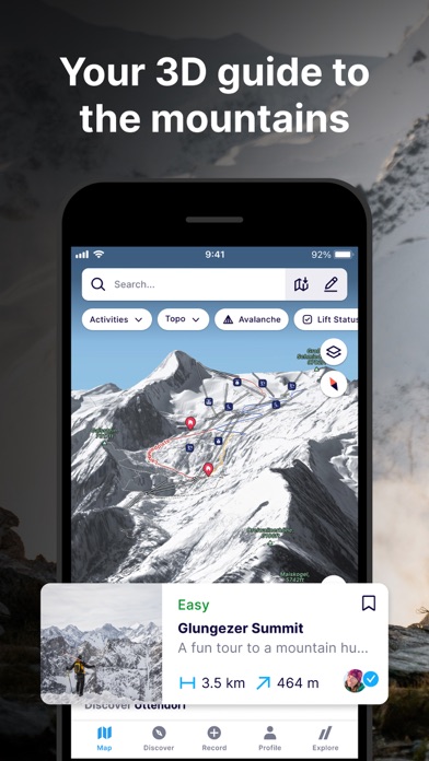
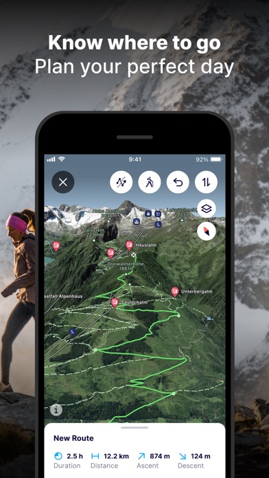
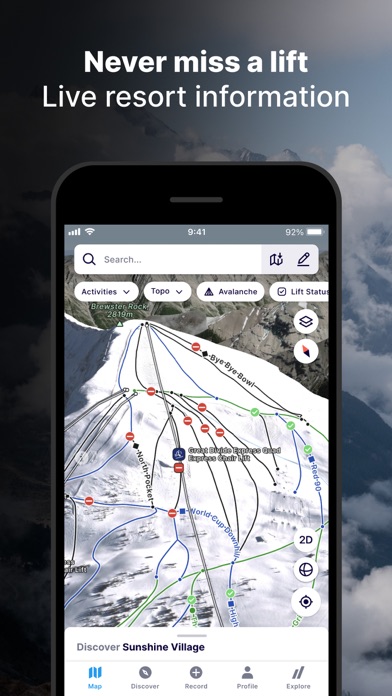
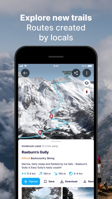
FATMAP: Ski, Hike & Trail Maps Ekran Görüntüleri

FATMAP: Ski, Hike & Trail Maps iphone resimleri 1
FATMAP: Ski, Hike & Trail Maps iPhone Ekran Görüntüsü 1
FATMAP: Ski, Hike & Trail Maps iphone resimleri 2
FATMAP: Ski, Hike & Trail Maps iPhone Ekran Görüntüsü 2
FATMAP: Ski, Hike & Trail Maps iphone resimleri 3
FATMAP: Ski, Hike & Trail Maps iPhone Ekran Görüntüsü 3
FATMAP: Ski, Hike & Trail Maps iphone resimleri 4
FATMAP: Ski, Hike & Trail Maps iPhone Ekran Görüntüsü 4