Two Steps Beyond
US Public Lands Customer Service

- US Public Lands Customer Service
- US Public Lands App Comments & Reviews (2026)
- US Public Lands iPhone Images
- US Public Lands iPad Images
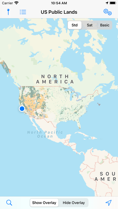
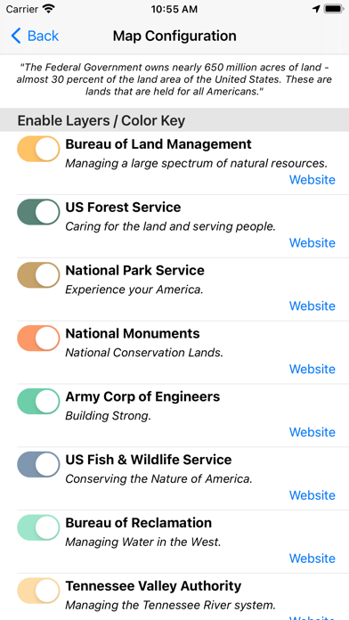
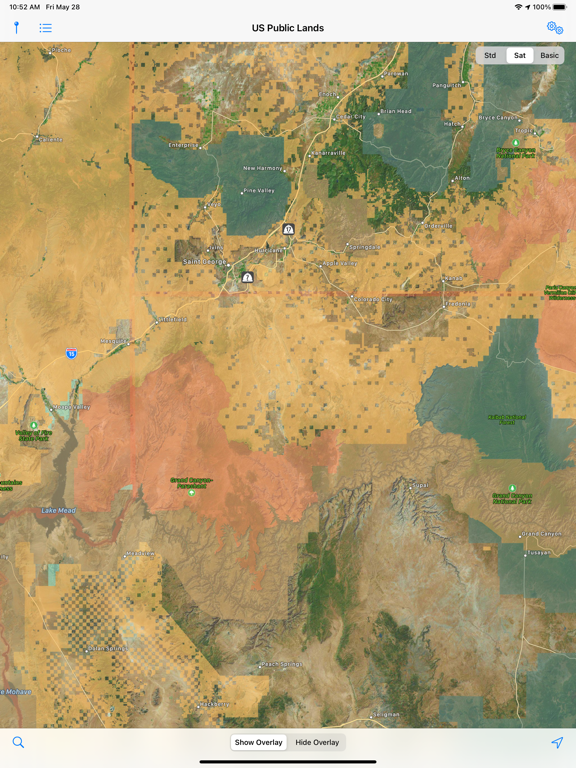
The US Federal Governments owns nearly 650 million acres of land - almost 30 percent of the land area of the United States.
These are lands that are held for all Americans.
US Public Lands allows you to quickly retrieve the boundaries of these properties without carrying physical maps, books, or digging deep online.
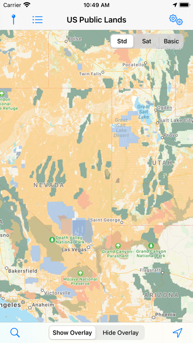
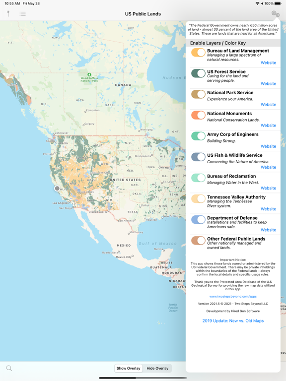
Included in the app are on-device (fully works offline), individually selectable & beautifully colored map layers for most of the properties administered by the federal government:
- Bureau of Land Management (BLM)
- US Forest Service (FS)
- National Park Service (NPS)
- Army Corp of Engineers (ACOE)
- US Fish & Wildlife Service
- Bureau of Reclamation
- Tennessee Valley Authority
- Department of Defense (military bases & installations)
- Other (National Laboratories, Test Sites, etc...)
Key Benefits & Features
- Know which US agency owns and operates the land you're on or are heading to. Use the "Layers" icon to select which agencies you want displayed to create your own custom map. (Hint, the toggles are color coded to the color each layer is displayed in.)
- Links are provided to each agency's website within the app, so that you can further your research as to what land use rules apply for each public land type - such as permits, fees, activities allowed, and limits of stay.
- Map layers are stored on device - no internet connection required.
- Be sure to turn on the 'Basic' base map to see the US Public Land labels for each land area. This base map layer is also stored entirely on your device, and can be utilized if you do not have an internet connection or would like to conserve bandwidth.
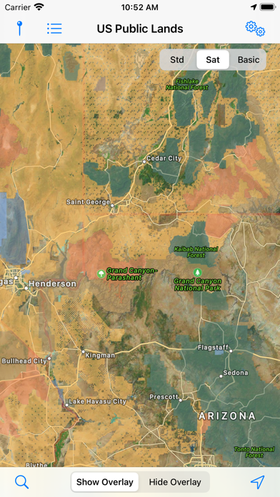
- If you have an internet connection (or have cached them before going out of signal), you can utilize the built in Apple Maps and satellite view maps as the base layer underneath the public land overlays.
- A boondocker's assistant - While US Public Lands is not specifically a camp site locator and does not have a database of specific sites, by turning on the satellite view map, you can better scout out trails, roads and signs of dispersed camping locations within the boundaries of the public land resources.
- Quickly toggle between 'Show' and 'Hide' via the "Map" icon to more clearly see satellite images below.
- If you have GPS access on your device, click the 'Locate Me' icon to show your present location - know what type of land you're on right now!
- Built in search tool locates anything on device maps supports (requires internet access) - including cities, states, zip codes, addresses and points of interest. A pin is dropped at the search location.
Thank you to the Protected Area Database (PAD-US) of the U.S. Geological Survey for providing the public domain raw map data that we’ve been able to utilize to create this interactive overlayable mapping & navigation tool. We will update our maps in the future to stay in sync with improvements to this data set.
Please note, the USGS PAD-US database contains the “most up-to-date aggregation of Federal lands and waters” available, but this database is still evolving and some locations may not be listed and others may not have precisely accurate boundaries. Resolution across the nation may vary. And always remember - there may be private unmapped inholdings within any public lands - so always pay attention to local signage, indications, and information.
The US Public Lands app should only be used as an overview, and you should always confirm more precise details by consulting local field offices, administration websites, and other resources. Do not solely rely on this app for determining if you are on public or private land.
US Public Lands App Comments & Reviews
US Public Lands Positive Reviews
Nearly UsefulWanted an app like this. It's close. The color overlay is ok except green areas because the default map color is green. Must squint and guess. Should let you tap to get management info about a the location. Maybe change default map color or allow configuration of overlay/map colors. Yes, you can choose "basic map" with white default color to help, but lose roads and whatnot. You can zoom in but some areas have fuzzy, gradient borders. Shouldn't the GIS data be very clear about boundaries?.Version: 2022.11
Brilliant app!The info you get from the government sites on where exactly blm starts or even where blm land is located is very hard to pinpoint. This app allows you to search by name and while not accurate to exact boundaries is more accurate than the blm website. The maps there are very hard to read while this one is overlaid on actual maps so you can figure out directions and get where you want to go. I like that it also covers other government land for you to stay on. This app is a must have if you love camping off the beaten track..Version: 2015.2
It does what it says it doesMy husband and I love 4-wheeling out to the middle of nowhere and staying a few days. Many times we’ve wondered if we were on BLM land or not. Now we know. I love that it shows your gps location on the map in conjunction with the colored map overlays. (Although I don’t believe it shows the coordinates.) If you’re looking for a basic app that shows if you’re on public land or not, then this is the app for you. If you need something that shows campgrounds and has all the frills, then look elsewhere..Version: 2015.2
Maps not vey accurateI purchased this app to help me find legal shooting locations on national forest land. Unfortunately, the detail and accuracy of the maps are not good enough for me to rely upon. I live next to national forest land, but the app shows that my house and all the homes around me are on national forest land, which they are not. Hopefully over time the maps will get better. Nevertheless, the app is well done. I just think it needs a better database to draw upon. I would like to see the national forest system put out more detailed information for app developers to draw upon..Version: 2022.11
Great for finding public landsThis is a great app for finding public lands but isn't quite as accurate as high dollar apps like Hunt. It's a great quick reference and is super helpful when roaming around the country looking for little pockets to boondock..Version: 2015.2
Love the New UpdateWith this new update any review more then 6 months old may not tell the whole story. With the new update to fully use the features you need cell service. But being able to have three different view. With satellite view you can see if there are other campers there. Then turn on the overlay to see who is the land manager. Great tool..Version: 2019.7
Yes, as advertised, but…This app will present you with a map that outlines public lands, assuming that you can figure out which shade of color or very limited symbology a particular spot may correlate with. It does little or nothing to provide even the most basic information on what the public land shown on the map is (name, etc.), let alone whether there is any access to it. I have rarely found it useful as a result..Version: 2024.7
Great app.Seems most of the folks writing negative reviews did not read the limitations of the app. If you know what you are buying, I think you will find this is an awesome app. It's not going to find a 100 acre parcel and says that up front. A square mile is 640 acres which is the stated accuracy..Version: 2015.2
AwesomeWhen was the last time you bought a paper map from the BLM office? And then how long did you use it? This app is SO much better and allows you to see where you are on the maps combined with satellite images. Thanks for building great tools..Version: 2015.2
Appreciated simplicityI use more detailed apps like Gaia GPS with premium layers to do deep investigation. But this app is great to have un the toolbox for its shear simplicity. Great for quick regional overviews to gather a sense of where to more granularly investigate. Thanks for making great use of these datasets, and implementing them in a clean and elegant way. Looks great on ipad..Version: 2019.7
Good but could be betterI like the satellite map with the color-coded overlay. You can see streets and figure out how to get places. But there's no measurement bar to indicate how large you've made the map or how far a place is from the highway. And as others have noted, small campgrounds or BLM dispersed camping areas don't show up. I can find these on free camping apps but not on this map..Version: 2015.2
ClunkyYou can’t copy the latitude-longitude of a spot you’re interested in to paste into Google maps. This is extremely inconvenient. It really only works for checking if you are, in fact, on public land already and is of little help finding where to go..Version: 2024.7
Needs ability to share/archive pin locationsI wanted to pin some of my favorite camping locations but found no way to share (with others or between different devices) or import/export. Also missing many public lands in PNW such as near port Angeles (especially state and county parks and DNR land ).Version: 2021.5
Very helpfulIt does does what it says it will do. I’m a boondocker and this helps me determine if I’m on federal land and what agency owns it. Used in conjunction with a camping app such as UC, you’ll be all set to head out into the wide open spaces..Version: 2015.2
New version of Publlic LandsLove the new app and detailed data.Version: 2019.7
Great App!This is an excellent app that makes our life so much easier. The developers have really improved it over the years..Version: 2019.7
Worth itTotally worth it however I'm disappointed that it doesn't show private lands. I bought it for camping/hunting/off-roading it would be also nice to be able to use as a turn by turn navigation with the iPhone..Version: 2015.2
I love this app!I use Public Lands all the time. We are full time RV’ers and we use the app to find or confirm public land boondocking sites. Highly recommended..Version: 2019.7
An essential for camping!This app alone is worth buying a smartphone for. You won't need to wonder where it's legal to camp. This app will tell you..Version: 2015.2
Amazing appI love this app and I have been using it for years. Great for cross referencing sat maps to find free places to camp..Version: 2019.7
Great app!Great App, does what it says it does. Very helpful. Would love to be able to "drop a pin" or similar, and get gps coordinates..Version: 2015.2
State Lands????Great app! Comes in very useful. I wonder though if/when state owned lands will be added?.Version: 2021.5
Best App for RVersWe use this app all the time for finding beautiful boondocking spots on public land. The new version with the overlay is amazing.Version: 2019.7
Great appWe use this all the time when looking for Boondocking opportunities. Love it.Version: 2019.7
Yeah... NOT SO MUCHSo i uploaded all 3 and my first Acquaintance with this app shows the”general” area however there are no difinitve markers to help me deal with the boundreys... its ALL VAUGE! Hope it gets better, be sure to read the reviews... IM JUST SAYIN!.Version: 2019.7
Not what I expectedThis doesn't really tell me anything about where I can camp. Just boundries of Government land. I guess I expected too much or misread the description..Version: 2015.2
Great appThis app is great for figuring out what public land you are on for camping etc..Version: 2019.7
Worth the money.Just remember, camp real close to the highway,much safer..Version: 2015.2
Great!!!Just told me i spent night on someone's private land! Whoops....Version: 2015.2
Helpful appOnly 4 stars because you will need to cross reference with google maps, but it's a really useful app for those who want to explore and camp in beautiful spots for free.Version: 2015.2
Nice update!This is a nice update to an already cool app..Version: 2019.7
Free International Money Transfer 💸Enjoy high maximum transfers into more than 20 currencies while saving up to 90% over local banks! The cheap, fast way to send money abroad. Free transfer up to 500 USD!Version: 2026.3