FATMAP: Ski, Hike & Trail Maps Customer Service

- CompanyStrava, Inc.
- CategoryNavigation
- Published2018-04-22
- Current Version3.26.11
- PriceFree
- Content Rating4+
- CompatibilityMin. IOS 12.4

- FATMAP: Ski, Hike & Trail Maps Customer Service
- FATMAP: Ski, Hike & Trail Maps App Comments & Reviews (2024)
- FATMAP: Ski, Hike & Trail Maps iPhone Images
- FATMAP: Ski, Hike & Trail Maps iPad Images
FATMAP by Strava is the #1 app for mountain sports.
Explore the mountains with confidence with the world's most advanced 3D outdoor map. Plan the perfect route, orientate and navigate along the way, record your day and share it with the community.
Whether hiking, biking, trail running, skiing, ski touring or freeriding, if you love mountain adventures, you'll find your community on FATMAP.
- Global 3D outdoor map with real-time information and offline maps
- Mountain biking, trail running, hiking, resort and backcountry skiing maps
- Stunning satellite terrain imagery, in summer and winter
- Record and re-live all your adventures in 3D
- Advanced terrain analysis tools including slope, elevation, avalanche and more
- Follow people to see their latest adventures
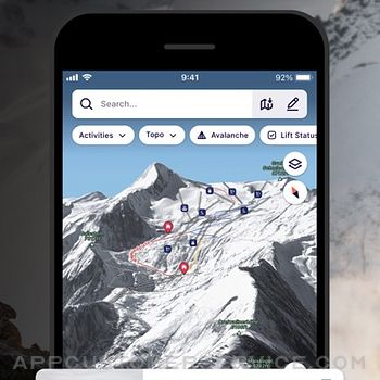
GLOBAL MAP FOR THE OUTDOORS
- Know the area like a local and plan your route in detail with the most advanced 3D outdoor map that helps you intuitively understand the terrain
- Find any outdoor trail: footpaths, hiking trails, singletrack and more
- Discover outdoor points of interest like mountain huts and campsites
- Choose between summer or winter/snow map imagery (where available)
FIND YOUR NEXT MOUNTAIN ADVENTURE
- Search and find the right route for you or be inspired by the community
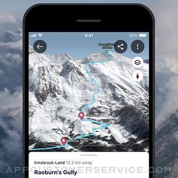
PLAN & NAVIGATE
- Create and share custom locations / waypoints
- Locate yourself on the map at any time
- Use peak names, roads, footpaths, rivers and heaps of other map data to quickly orientate yourself and navigate to your next objective
- Navigate trails while riding, hiking, running or skiing
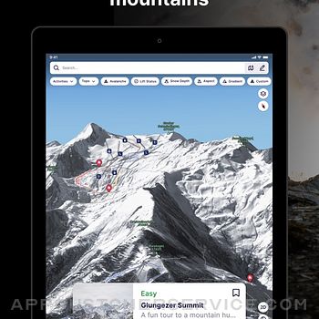
UNDERSTAND THE TERRAIN LIKE AN EXPERT
- Understand the terrain like never before to make better decisions with Gradient, Avalanche, Flats, Aspect and more layers.
RE-LIVE YOUR ADVENTURE IN 3D
- Track your adventure in the app or connect with Suunto, Garmin or Strava to see your tracks in 3D
- Share amazing fly-throughs of your adventure
GO FURTHER WITH FATMAP EXPLORE
FATMAP Explore is for everyone who wants more out of their outdoor experiences.
TOPO MAP LAYERS
- Use the Global Topo map or see official topo maps from swisstopo, USGS, IGN, basemap.it and more in 3D
REAL-TIME SNOW CONDITIONS
- See current snow depth, fresh snow, and snow forecast directly on the map.
REAL-TIME RESORT STATUS
- See which lifts and pistes/runs are open or closed in real time. (At supported Ski Resorts)
OFFLINE MAPS
- Download any part of the map and use it without an internet connection.
- Conserve battery by using the app in airplane mode
THE BEST DEALS ON OUTDOOR GEAR
- Explore members receive discounts in major partner brands like Mammut, Salomon, Suunto, Faction Skis and many more.
(Access to FATMAP Explore requires a paid membership.)
- REVIEWS -
“FATMAP has changed the way I see and act in the mountains” - Xavier De Le Rue, The North Face Athlete
“Useful and inspiring (and also looks really really cool.)” - Forbes
"[FATMAP] may be the most ambitious adventure tech to hit the market since sat phones" - Outside Online
“An app that will revolutionise your backcountry freeriding experience” - Red Bull
** For technical support, contact: [email protected]
FATMAP Explore is available as a 12-month subscription. You can subscribe and pay through your iTunes account. Payment will be charged to your iTunes account at confirmation of purchase. Your subscription will automatically renew unless cancelled at least 24 hours before the end of the current period. You may manage your subscriptions and turn off auto-renew after purchase by going to the ‘Manage Subscription’ page in settings. Any unused portion of a free trial period, if offered, will be forfeited if you purchase a subscription, where applicable. The subscription will renew at the same cost."
Terms of Service: https://about.fatmap.com/terms
Privacy Policy: https://about.fatmap.com/privacy
FATMAP: Ski, Hike & Trail Maps App Comments & Reviews
FATMAP: Ski, Hike & Trail Maps Positive Reviews
Revised ReviewAfter having significant issues with my login I reached out through the FB community. The App developer got back to me, explained that the issue I was having was from a known bug. They were able to do a manual reset allowing me to access my account. Now no issues although I’m not sure why a known bug was allowed to stay present. Thank you.Version: 2.25.5
Quickly becomes indispensable and addictiveThe level of detail in 2D and 3D maps is extremely useful to accurately plan routes. The ability to take a map onboard has helped me orient when exploring unknown new routes. The ‘flyover’ overview has become a priceless way to evaluate new routes and to relive (and share) great adventures. The growing volume of crowd-sourced data is helping create a repository of first-hand information on trails that more generic mapping software can’t provide (though you are in direct control of what personal data you share.) The “Guidebook” feature is a convenient way to document the best routes of your choosing, including notes and photographs. Superb already, and getting better..Version: 3.26.6
Coolest mapping software in historyThe team at FatMap are obvious legends of the mountains as they have made an incredible piece of software for adventure enthusiasts from a usability perspective. How other popular apps have not gotten on the 3D orientation game perplexes me. Layer in avalanche slope terrain and you have the most powerful and user friendly route planning app I’ve ever seen. I’ve used Gaia, Strava, caltopo, AllTrails, MTBProject, and many others but always come back here. Only advice for the team is to keep layering in the more advanced features that professional adventure folks are willing to pay for in regards to route planning like real time weather integrations..Version: 3.24.25
FATMAP love + feature requestI’ve been using FATMAP for a year now for all my backcountry tours and backpacking around the world. Creating routes and downloading maps is easy and effective. One feature request that I have is a modification of the Waypoints feature. It’d be nice if there were several color options for how they appear on the map. For example, I like marking some backcountry snowboarding “runs” with one color, say blue, and then it’d be nice when I mark a fork or a pass or a peak with another color, so they don’t get mixed up. That’s all I got. Still loving the app and integration with Strava..Version: 3.24.34
Best app for exploring outdoor terrainI now go into my outdoor activities much more informed, and enjoy them a lot more too. I appreciate the level of zoom detail, 3D capability, fly-over feature, Terrain Layers, and Snow Depth. Truly exceptional features. Thanks for this awesome app! It would be great to be able to overlay the Distance layer on top of the Snow Depth layer. That way I know how long I’ll be traveling over snow to get to my destination. Toggling between the two layers gives me a rough idea but is kinda cumbersome..Version: 2.19.0
Excellent for hikingI’ve used this app for over a year for hiking. It has all of the trails as well as cross country ski trails, forest roads, snowmobile trails, etc. The 3D feature is very helpful. I download the maps before I head outdoors. The app works on Airplane mode and I can always see where I am and where my next trail junction is. It’s never steered me wrong or let me down. Love it..Version: 3.26.4
Fantastic app for adventuresOne of the best apps around! This app is indispensable for outdoor adventures and objectives. I also use Gaia and CalTopo but always use FATMAP as well. To me, FATMAP is more unique and has some fantastic features. It’s easy to download maps for offline use and the explore membership is well worth it as well. Overall, I couldn’t recommend this app enough!.Version: 3.24.1
Best outdoor planning appBeing in the mountains all the time, you realize how helpful and safe it is to have a plan of where you are going, where you are sleeping, and how you can get out. FATMAP helps with all of those. It’s like being able to hold the world in your hand and look into any tiny piece of detail before you get there. It’s great.Version: 2.25.5
Some easy fixes would helpI use it to orient myself to new ski areas before I arrive or maybe after a day or two, and it can be great for that. One huge annoyance: when you press a ski run to see its name and get info, the entire view reorients itself - I guess so you can see the entire run from an angle the developers like. Super annoying to have to re-orient the map manually each time I highlight a run. Makes me afraid to highlight a run at all Please fix this!.Version: 2.13.0
3D Maps, and offline!!This is the only good app that has offline 3D maps. It’s huge compared with no offline, and usually no 3D maps at all. The map visualization is very smooth, even when u add tons of waypoints to it. Great great implementation of the 3D map, better than G_Earth. Easy to share with friends!!.Version: 3.21.6
Nice updateI am mostly interested in this app to plan backcountry ski tours and the last update fixed the glitches when downloading terrain and slope gradient layers. It’s pretty neat to be able to pan around in 3D with the slope gradient overlay. It would be even better with slope data over the topo layer similiar to caltopo..Version: 2.5.0
A useful tool for fun in the alpine!I usually use Gaia or CalTopo, but FATMAP may soon replace those apps as my go to tool for mapping. Its slope angle shading tool is handy for planning backcountry ski trips and approaches / descents in new terrain, and I appreciate how easy it is to share route and route information, with my colleagues and my clients. The 3D view is fun, too!.Version: 3.24.10
Great potential, needs improvementExactly as the title says, the idea is there, but needs a lot of work. I have faith in this one, meanwhile I’ll use my usual go to apps and keep an eye on this one. I’m in NYC, very little coverage on this app here, but again, this is a relatively new app and I’m sure it’ll keep expanding its database and functionality..Version: 2.10.3
A step in the right directionOverall I find it useful for backcountry skiing, but it’s missing a couple features that will prevent me from renewing. 1. You can only import a gpx route from a computer, and not directly into the app from you iPhone. 2 Downloading offline maps is problematic. It’s slow to start( if at all), and takes forever..Version: 3.24.8
Excellent , impressiveThese guys have put some work into this app - and it has become outstanding. Exceptional high res downloadable 3d maps. Really cool data on trails. A premium subscription is not cheap but I may be canceling my ONx subscriptions for this one. Recommended..Version: 3.26.6
Best back country app out there!Hands down the best and easiest app for plaining backcountry routes! Super easy to navigate and excellent customer service! Also pairs seamlessly with other navigation devices including Garmin Inreach! Highly recommend and will alway add this into my planning on any adventure!.Version: 3.14.1
Beautiful app for outdoor enthusiastsFATMAP has accurate topography and beautiful 3D visualizations. I use it, and help teach others to use it, when I am evaluating my planned route for a mountain adventure. The connectivity with STRAVA is a fantastic feature to let you review your tracks in 3D. Well worth the download!.Version: 2.25.4
Continuously has to renew purchaseThe app is phenomenal, but every single time I open it I have to renew my purchase. It has become extremely frustrating, multiple times mid-download of an offline map the download has cancelled because the app wants me to hit a button to renew my purchase….Version: 3.24.20
Winter Satellite Imagery Rocks!The winter satellite imagery alone is worth downloading the app for if you are a Backcountry skier. Couple that with 3D aspect, elevation, and slope angle data and this app is A+ for trip planning unfamiliar avalanche terrain. It would be awesome to see more areas with winter imagery uploaded! Thanks FATMAP for creating a super useful product! -Brad Maddock owner Montana Backcountry Yurts.Version: 2.25.4
Bomber for the backcountryStarted using this last winter and wondered why I haven’t been using this app my whole life! Awesome data for planning backcountry ski missions, finding safe snowmobile zones, and getting into and out of remote wilderness river canyons. If you recreate outside, this is a must!.Version: 2.24.2
So usefulLoving this new update. When organizing an outing for myself or with clients, it is so smooth to put it on the map and share with others. Planning any outdoor activity reached new level. I am super stoked with topographic layers! This on its own is a game changer..Version: 3.1.0
PromisingIt lacks plenty of routes , or in too new to it that u can’t find them easily. I wish it was also on Apple Watch. The offline maps area to download are too small, I’d like to be able to select a much larger area at once. Other than the above , this app offers great maps, with lots of details and impressive details such as orientation maps and so forth, if the three points above could be improved then this app would be stellar..Version: 3.26.11
Very nice app!This definitely has better imagery than google earth app and the in app slope overlay is very nice! Still new to this and Will update review to 5 stars if I can figure out how to get tracks and routes to work..Version: 3.22.1
Was expecting moreWhen I import a GPX file, it only saves the track not the individual waypoints. Which is useless to me when I create a file with different way points and tracks it should all save in the app..Version: 3.24.27
My Bachelor Oregon needs updatingAnd the names of the runs need to be updated as they have changed at Mount bachelor ski resort in Oregon. Also, the summit chair lift is not shown..Version: 3.24.34
Uhm, can’t subscribeI’d sign up to test for a month but I can’t. When I select “subscribe”, pop up shows me middle of page and I can’t scroll up or down to go thru sign up process. You don’t give me much confidence that this will work when I’m deep on a trail and need to figure out my way..Version: 2.9.1
Awesome with StravaThis pairs so well with Strava. I really like the Strava route builder, but I have found their biking suggestions very much lacking. Fatmap’s recommendations are really great, and the flybys are useful for unknown mountain bike routes..Version: 3.26.4
Super cool!Inspiring to see places both I know and could go to, and maybe one day I could download certain areas offline and explore the rugged planet accordingly, like a mobile Google Earth..Version: 2.7.2
Best ski run maps everI downloaded this for the free preview for an upcoming ski trip. It gives AMAZING detail on ski runs, not only maps and multiple views, but writeups on many of them. A great resource for traveling and skiing..Version: 2.25.5
One of my most useful apps period!This app is my #1 tool for scouting for archery elk hunting in September. The many layers are a huge asset and have changed the way I scout and hunt for elk. Don’t know what I’d do with out FATMAP!.Version: 3.2.1
Impossible to usThe search doesn’t work well. You can’t select ski runs on the map to see their info. Although I like the idea of an interactive 3D ski map..Version: 3.26.11
The best app for skiingMuch better UI than others and the gradient map is unique.Version: 3.24.25
Accurate InformationFATMAP displays beautiful terrain representations accompanied by very accurate route information..Version: 3.8.1
Best mapThis is so good. 3D terrain images. Tons of existing routes and can make your own custom map..Version: 3.1.6
Great tool!Just started exploring Fatmaps, looks like it will be an amazing tool for backcountry navigation!.Version: 3.22.3
A Completely New PerspectiveThe FATMAP app has provided a completely new perspective when it comes to planning, navigating, and tracking backcountry adventures. It’s a tool I’ll be using for years to come!.Version: 3.25.3
MehLove the maps and 3D features but planning routes is clunky and complicated. Cant even measure a distance without being “online” / in service. Even when i have the maps downloaded to my phone. Thats my biggest gripe and its caused me to switch to a different map system..Version: 3.26.7
Amazing qualityLove being able to see all layers in 3D offline when I’m in the back country.Version: 3.24.26
Awesome mapping appFATMAP is an easy to use great quality mapping app. A great way to keep track of your mountain adventures!.Version: 3.24.26
Best app for ski touring and trip planning, bit a questionI’m still relatively new to ski touring and understanding terrain is the trickiest part about navigating in the backcountry. This app helped me incredibly in planning my trips, working through avalanche terrain and being able to access areas of the backcountry I never thought I would get to. A must have for a backcountry skier.Version: 3.24.25
Great AppI use Fatmap all the time in Northern BC. It’s the best tool especially using the downloaded map feature..Version: 3.24.25
HikingBest app I’ve ever used for navigation. Amazing 3D imagery and loving being able to make my own hiking route..Version: 3.24.21
Good for planning new routes. Bad for managing old onesThe best tools and visuals for planning ski touring routes. It’s frustrating that the platform is designed around promoting other people’s routes. I would like the option to see all my routes and adventures on the map at the same time. Why are the full routes not shown in the guidebook map view? Great work! Keep it up.Version: 3.24.17
Very useful app!I love how easy is to navigate and read the terrain in this app. It features really useful tools for winter and summer, ex aspect and gradient. My favourite things is to see the terrain in 3D as it is. Easy to figure out where you are at all times..Version: 3.24.17
Great appGot this app based on the review from a friend and love it for finding routes near me that others have done recently as well as navigating..Version: 3.24.14
Whiteout best toolVery useful for guides in a whiteout.Version: 3.24.14
Fatmap Rocks!Amazing app, it really changes the way I navigate in the mountains! Thank you Fatmap!.Version: 3.24.12
Good potentialVery comprehensive maps. However a few things are not working properly. To download a map, you have to actually stay on the Offline maps/download section. If you navigate somewhere else, either IPhone or app, it's stop downloading. One last thing, I went on a big ski tour yesterday while I tracked everything. On the skin up, the tracking worked fine. On the ski down, about halfway, it stopped recording my precise location, and drew a long straight line all the way back to the sled. It's hard to trust this app anymore....Version: 3.23.2
Oh god it’s frustrating to useEvery single accidental touch opens something or zooms to another location. Terrible UX.Version: 3.23.2
The go to for ski planningFATMAP is my go to for BC planning. The 3D view really helps to visualize my routes..Version: 3.23.2
Best map for backcountry travelSo far this is the most comprehensive map I have found for backcountry travel. I primarily use fatmaps for skiing and alpine climbing as it gives me the ability to look at multiple layers and details about terrain..Version: 3.23.2
GreatApp.Version: 3.21.1
Amazing Mapping AppFATMAP really enhanced our backcountry ski day today by easy to use wayfinding and LOTS of other tools and information. Recommended for anyone looking for adventure! Great to sit down this evening and plan the next one as well!.Version: 3.22.1
One of the Best Maps Out ThereFatmaps is so powerful especially for back country avalanche terrain. It has calculated slope angles and tells you what would be high risk vs lower risk which is so cool. Highly recommend the paid version 👍🏼👍🏼 It’s a learning curve to use but its great after you get the hang of it..Version: 3.22.1
Best appThis is a must get app, the 39.99 is absolutely worth it for life saving information and time saved by getting accurate and up to date info. I highly recommend this app to anyone who gets outdoors and wants to explore. I also appreciate the learning and time this app takes to teach you its features and how to properly use it. I cant speak for everyone but this app is worth every penny. Thanks fatmap!.Version: 3.21.14
Great ProductUse fatmap consistently for professional use in the mountains. A unique product that offers a great perspective that very few products have.Version: 3.21.6
Maps out of dateGreat app, works awesome however, the maps quickly become out of date in heavily logged areas and forest fires. Wish they were updated yearly.Version: 3.8.1
Elle marche à merveilleJ’ouvre plus mon garmin depuis ….Version: 3.19.9
Everything in oneBig fan of the layer, navigation, planning and field use of fat maps. It’s very intuitive and in-depth. 10/10 telling all my friends..Version: 3.19.1
Easy, helpful, and just coolI love FATMAP for trip planning. The layers make it so easy to take a quick glance at an area and plan a safer touring route. Having other peoples trips recorded too can help you stay on track or change your route on the go. A great tool to have!.Version: 3.18.0
Very useful app for planning mountain travelI have been using FATMAP for the past 3 years. The app is very useful for planning trips for all kinds of mountain travel. In particular, the slope angle shading layer is valuable in pre identifying avalanche terrain for ski tours and the custom aspect layer is great for figuring out where the best snow will be found for the conditions. I would recommend FATMAP to all backcountry travellers..Version: 3.18.0
Amazing Mapping App!Get this app! Amazing imagery and mapping tools. You won’t regret it. Best map app I have ever used!.Version: 3.15.2
Amazing tool for the Backcountry!I had heard good things about the app from friends but really didn’t realize its true value till I recently took my Avalanche Skills Training Level 1 course. Extremely helpful in pre planning routes and up tracks as well as descents. Many layering options aid in identifying terrain areas to avoid. Doesn’t replace experience or common sense, but just gives you a enhanced perspective so you can hopefully make safer decisions out there. Haven’t tried it yet for Trail running or biking but I’m sure there will be advantages..Version: 3.15.1
Great App For Trip PlanningSuper useful for trip planning, especially backcountry skiing. Good satellite imagery, the option to view most terrain in winter and the various filters (slope angle, aspect) are all really helpful in forming a mental map of terrain before you’re in it..Version: 3.13.2
Great productThis app has been so helpful for ski mountaineering. I am always finding new lines using the satellite imaging!.Version: 3.13.0
Essential modern tool for backcountry skiing.Simply put, if you ski tour you need this app to plan your day and access the goods as efficiently as possible! The images are amazing..Version: 3.12.0
Amazing graphicsNo other app has imagery as good as FATMAP. Thanks!!!.Version: 2.25.5
Beta beta betaThe more information you can get in the backcountry the better. I’ve been watching Fatmaps grow over the past few years. Really impressed with the platform and high resolution maps!.Version: 3.1.11
AmazingBest app out there for detail.Version: 3.1.8
This app is absolutely awesome!You’ll never go back to 2D again!.Version: 2.25.5
Amazing detailsHave used it to find trails I would never have found using any other app..Version: 2.25.5
Great App, request drawing supportThis is fantastic for planning your day on the mountain, would really like to see drawing support so i can use my apple pencil to plot lines I would like to hit, or use as a tool to discuss how to access areas of the mountain. Great Job. Keep it up!.Version: 2.25.4
Hell yeah!Game changer for backcountry skiing! No winter mode for BC/Alberta but hopefully that comes soon..Version: 2.25.4
Excellent Premium App for SkiingAs trio planning apps go this is one of the best. While it lacks the off grid capabilities of Gaia it is far superior to Google earth. Being able to swap between season gives you a much better sense of terrain, particularly for feature like glaciers. In the deep backcountry you also get far better image quality than you get with google earth. The avalanche risk function is also handy for finding the best routers on traverses an similar terrain. Definitely worth the money..Version: 2.25.4
Free International Money Transfer 💸Enjoy high maximum transfers into more than 20 currencies while saving up to 90% over local banks! The cheap, fast way to send money abroad. Free transfer up to 500 USD!Version: 3.26.11
What do you think FATMAP: Ski, Hike & Trail Maps ios app? Can you share your thoughts and app experiences with other peoples?
Please wait! Facebook comments loading...