 Cascode Labs Pty Ltd
MilGPS Customer Service
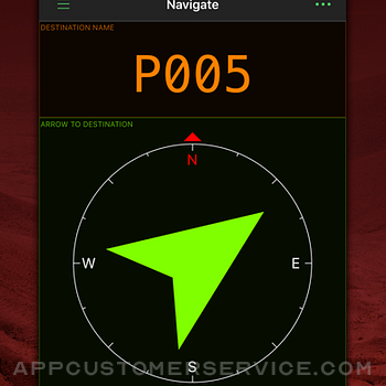
MilGPS is an MGRS/USNG focused premium navigation tool trusted by soldiers, search and rescue personnel and other professional navigators around the world. View your current location and navigate to a waypoint in seconds. Or plan and organize your navigation using the powerful and intuitive mapping and overlay capabilities.
FEATURES
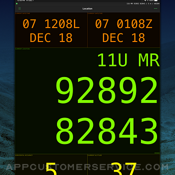
Display your current location in real time
- Cell phone signal not required but will make location fixes faster (maps require a data connection)
- Military Grid Reference System (MGRS) & United States National Grid (USNG) (4, 6 8 10 figure grid references supported)
- Universal Transverse Mercator (UTM)
- Latitude/Longitude (degrees, degrees and minutes, degrees minutes seconds supported)
- Ordnance Survey National Grid (grid and easting/northing in metres)
- Military date time groups for local/zulu time
- All info is displayed in large, clear text for easy viewing at all times
- Location and navigate screens are fully customisable - choose what info you want to see
- Wide variety of datums supported including WGS84, NAD27, OSGB36, AGD66, ED50
- Define up to 3 combinations of datum and location format for location display and waypoint entry
Create and navigate to waypoints
- Unlimited waypoints (upper limit dependent on device storage and memory)
- Enter waypoints from current location, map or using any of the above supported location formats.
- Live update of distance/bearing as you enter coordinates (sanity check your grids)
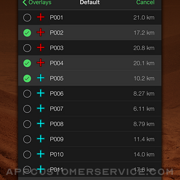
- Waypoints are fully editable, and can be sorted by distance or name
- "Quick goto" feature for quickly entering grids and navigating to them - accepts shortened MGRS grids.
- Receive an arrival indication as you approach your waypoint
- Import and export waypoints via the standard GPX file format (routes and tracks not currently supported)
Mapping
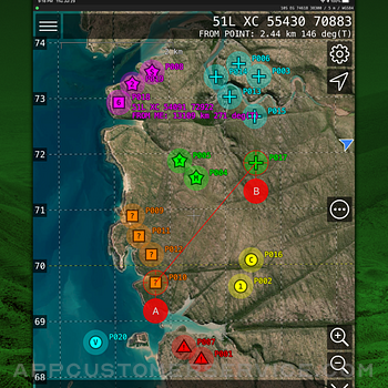
- View current location and waypoints on map, complete with custom smooth scrolling grid overlay (MGRS/USNG/OSNG/UTM)
- Choice of Apple or Google maps.
- Display user-supplied offline maps in raster MBTiles format.
- Use the crosshairs to position new waypoints and measure distances/bearings
- Choose from standard/satellite/hybrid/blank map type
- Grid overlay with labels for grid zones, 100km, 10km, 1km, 100m squares
- Map can be set to follow your current location and/or heading.
Other features
- Simple, intuitive interface.
- Supports a wide variety of location, angle, altitude, and distance formats.
Why choose MilGPS over other apps?
- MilGPS is under active development and testing (since 2010)
- MilGPS is painstakingly crafted by an independent developer
- MilGPS emphasises accuracy, simplicity, ease of use and stability
Things that aren't in the app (yet):
- track recording
- route planning
- online mapping sources other than Apple and Google maps
App Store Privacy Information Note
Because you can choose to use Google maps in the app, we are required to disclose the data collected by Google in our App Store listing. If you do not use Google maps minimal data is collected. See our privacy policy for details.
NOTE: Mapping function requires a data connection. WiFi-only iPads are not supported because they don't have a GPS receiver. Using GPS will shorten battery life.
WARNING:
YOUR USE OF MILGPS IS AT YOUR OWN RISK
MilGPS is an aid to navigation only and is intended to be used in conjunction with other navigation methods and tools.
MilGPS must not be used where relying on MilGPS could result in death, injury or financial loss. This includes use on military operations, live-firing activities, aviation and surveying use.
MilGPS is not tested to military specifications and is not endorsed by the military of any nation. MilGPS is not a substitute for military issue equipment.
Your use of MilGPS is governed by the standard App Store Licensed Application End User License Agreement.
MilGPS App Comments & Reviews
MilGPS Positive Reviews
Initial Impressions: ExcellentCompared to the two GPS apps that I have used often (LandNav and Spyglass), MilGPS immidietly seems superior and best suited for my military training purposes. Readout is HUGE and responsive and I will probably stick with the default look. Maps come up quickly and it was easy to customize (Apple/Google are adequete, but more map choices would be great). Design layout could be slightly improved by having more intuitive button placements (e.g., Edit Screen is hiding in the Share menu, and cancel button was hard to find on one screen), and maybe a bug: Navigate → Share → Choose Destination Waypoint took me to Overlays (I'm probably missing something). Ideally, I would like a mini-app to quickly send an 8-digit grid to the clipboard and close, since I share locations often—every step out in the field counts. For my purposes, MilGPS makes sharing an 8-step process (i.e., Open → Share → Share Current Location → Message → Tap x2 in message field → Select All → Isolate MGRS grid → Tap ⌫). MilGPSs is more intuitive than LandNav, but it would be nice to simply 3D touch a readout and send custom data to the clipboard. Future updates perhaps? Not sure why it took me so long to find this in the App Store. Downloaded USNG first, and then found MilGPS via 'Also by This Developer' in the sidebar. Kudos to all those who helped develop this app, good job!.Version: 6.3.0
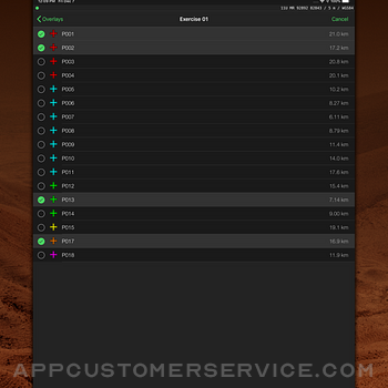
Good for military or other usesThis map has a good layout that doesn’t take too long to figure out. It allows you to utilize “overlays” which means you can create permanent overlays that you can always leave on or you can create a new overlay for a training exercise and then turn it off when your done and remove the points. The pay version isn’t expensive a d if you’re going to use it a lot then I would highly recommend paying for it. Additionally they have multiple shapes and colors you can use to make points unique and you can further specialize them by naming them and adding descriptions. A cool feature I didn’t realize existed was that you can send overlays you’ve created to people with the map. This means if you’re going into a new training area then someone can send you their overlays or you can help someone out and do the same. Overall it’s well designed, easy to use and you can get pretty specific with points. There’s also a moveable scale so you can figure out the exact distance and direction between 2 points. Overall I love the app and use it every time I go into the field. Some features I wouldn’t mind seeing are: - lines to connect points so that you could construct boundaries. I would use this to form the boundaries of training areas and impact areas. - the ability to change the direction of the ruler from degrees to Mils..Version: 6.10.0
Excellent Nav AppAwesome app and awesome developer. I only had one issue with the app- and that was when zooming in or out, the map had a tendency to twist- but after a few emails with the developer explaining what I was talking about, he updated it with an option to lock orientation north. Super useful! Actually, as I type this is thought of another issue. When you tap the icon to center on your location and follow you, it automatically zooms in. It would be nice if there was an option to leave the map at the same zoom level that it’s currently out but still be centered on, and follow, your icon. Sometimes I want to be centered on my own icon but don’t want to be zoomed in super close. But other than that it’s a great app. I use it every day at work..Version: 7.4.0
One of the best gps from military sideFirst off I did come from ATAK. At first it did feel a bit featureless. But after progressing by start of small like using it to plan a hike then to using it on the field for military exercises. Because I have an iPhone and an ipad, it is actually very easy to move points from one device to another and it’s great. The accuracy isn’t garmin level but for using it casually/a secondary tool/ an 8 dollar garmin is a steal. Now the reason why I give it 4 out of 5. I know it’s a bit selfish but please make an Apple Watch support. It would be a lot more convenient to view the navigation page and the points on the watch than phone. You would easily become better than my garmin. I know it’s a bit accommodating for one customer but as someone who doesn’t review, you would have a huge potential. All I’m saying is if Apple can have maps on the watch work, it can be done.Version: 7.4.0
On MFing pointI bought this app a few years ago, when I was still in the Army, back then I paid $10. I used it as secondary/backup/check-location-accuracy. Since it was on my phone, it couldn’t be my primary source. My primary source was a wrist Garmin GPS, I would (discreetly) open this app and check my position, both, my Garmin GPS and this app were always on point, may be 1-2 meters off but that’s nothing since we used a 10 meter margin of error. I’ve always loved the satellite image because it allowed us to plan better when picking routes of travel. For a one time payment, the accuracy it has and all the things you can do, $10 is a steal. Highly recommend this app, I have and keep doing it when the subject comes up..Version: 6.4.1
A solid App!I downloaded this and got going really fast. The active overlay and visible overlay took a bit to figure out but not a big hurdle. I used this to map location of items during a field test. Worked great. The challenge is using the files upon export. The icons used all translate to the basic point name. For example, I used green crosses for one position and orange triangles for a subsequent position. Google earth makes them all a single color pushpin once kml exported. GPX export rendered boxes. Luckily I named the point distinctly. Giving instructions on how to retain map attributes in the user guide would help tremendously. Otherwise note that all points will visually look the same upon export. This a a great app though. Excellent for on the ground recording and the accuracy is good enough! I’d definitely download and continue to use..Version: 6.8.2
Excellent appSustains: Flawless performance, been using this app for years now without encountering a single bug. As long as the app stays running, whatever you have loaded already will stay loaded regardless of wether or not you have service, which is a big plus. Great tool for Land Nav. Monitors and displays your current National Grid location, and includes nomenclature as well. Also adds grid coordinates for placeable icons as well as your distance from them. Icons can be sorted into separate overlays that can be turned on/off. Improves: More placeable icons would be great. Preferably NATO standard map icons. I would pay for the app again if that were an option. A feature to allow connecting with other devices that can see each others locations and share overlays would be awesome as well. You’d pretty much be able to have a poor-man’s Bluforce tracker at that point. I’d pay for the app again several times over for that. With all that said, awesome app, worth the money..Version: 7.5.1
Small improvementsThis is absolutely a great App, ive been using the app for around 10 years and even after trying different apps that are similar i still end up coming back to this app. I use the app significantly while hiking but also during training in the military because the app is easier to use and more reliable than ATAK. A few things that i believe would improve it would be offline maps, topographic and google/apple maps. This would just make navigation easy with or without cell service. Being able to download even just sections of a map, topographic and google/apple maps, would be perfect and not take up as much space on the device. A significant issue that i have seen was when zooming in on the topographic maps the contour lines disappear when you zoom in close to an area. This makes it challenging to choose the best route or see what terrain youre getting into. Another nice to have feature would be the ability to make routes. Having this would make long distance navigation significantly easier. Thank you for your time and for making this incredibly reliable app, its been a huge asset both on hikes and also at work. Ian.Version: 6.10.0
Overall, okayIt’s a good app and has a lot of features. I love being able to customize the navigation screen especially when working with two gps formats simultaneously. Also, location sharing via text is outstanding and relays all the necessary information. I don’t feel the UI is very user friendly or intuitive. For example, I am unable to enter coordinates from the map screen. I can place coordinates at my current location and at the crosshairs on the map, but I can’t simply enter coordinates from the map screen. I have to back out to another screen completely. And to copy coordinates from a website and paste into the app is terribly awkward. In fact, having to enter coordinates quickly is very difficult because of how buried in the UI that feature is. If you’re geocaching and have all day to fiddle with the app to enter coordinates, then you won’t have any problems. If you have to quickly plug in coordinates from your hunting party, a mayday or dispatcher, use another app or gps. Also, downloadable maps for app use independent of cell service would be helpful in poor coverage areas. Just a thought..Version: 6.4.1
AwesomeAbsolutely stellar! This mapping app has completely transformed the way I navigate through my day. With its intuitive interface and accurate directions, I’ve never felt more confident getting from point A to point B. The real-time traffic updates have saved me from countless headaches, and the offline maps feature has been a lifesaver in areas with spotty reception. Plus, the integration with public transportation schedules makes planning my trips a breeze. Overall, I couldn’t be happier with this app’s performance and functionality. Five stars all the way!.Version: 7.15.0
RangerThis app is amazing. I use it for almost everything i do. I use for doing reconnaissance work such as taking a screen shot and then drawing in the sea wire, Vic, guard positions. I also use it for almost all of my route planning. The only improvement i would like to see is if i could actually draw on the terrain in app then having to use another app to do it. Other than that the maps are always up to day and have absolute precision on grids. The arrow can be shaky at time. But that’s why you always use a compass. Other than that highly recommended this app and will continue to use it. RLTW.Version: 6.5.2
Great App( PLEASE MAKE APPLE WATCH VERSION)Overall great app with an amazing user interface that's super easy to use. The app does everything I need to do quickly and easily, and it’s accurate and precise. The only thing I wish is that there was an Apple Watch version so that I wouldn’t need my phone to put in coordinates and get directions but to conclude, compared to other apps for the one-time fee, this is a fantastic app for money. I can recommend it to anyone who needs a land navigation app..Version: 7.8.0
Best GPS in App StoreThis app has so many good features it is hard to summarize. The location and navigation screens are completely customizable display of the fields, location/size and units. (10 stars). The map screen allows you to choose the type of map to display (street / hybrid / satellite). (5 stars) The overlay screen allows you to organize waypoints however the waypoints are difficult to choose to navigate and you must be careful not to accidentally edit/delete the waypoint when selecting to navigate to the point. (3 stars). The settings screen should allow for a default for waypoint navigation screen (e.g. map or navigate screen). (4.9 stars). I have used many of the GPS apps in the App Store. This is the best. A few minor enhancements would make the app perfect. This is a must have app for hikers or navigating in an unfamiliar city..Version: 6.5.4
Works like a charm for amateur land management.I use this app to help me locate and manage the corners on various pieces of remote property. The exact locations were/are gathered by our surveyor but MilGPS gets me within feet of our flags, stone monuments, or iron pipes that mark the various corners of our property. Has never crashed on me and always gets me within feet of the corner. Also very easy to store different points and organize them by parcel instead of one long list. Very customizable and reliable. Has absolutely been worth the price..Version: 6.4.0
From military to civilian perfectI’ve been using this app for years. May be one of the first to buy this app when it first came out. From using this app in the military to civilian usage, it’s perfect. If the others have the app it’s easily sends to others if they don’t it will simply pull up on google. Doesn’t matter what format of map reference you uses or if you need to use multiple types it’s easy to set up for you. Love it.Version: 7.3.0
The best you can getThis is by far the best app that I have had. It has helped me in so many different situations and once you get the hang of plotting grid points and learning how to use the system it really does make a difference. Been using this app for several years now and I’ve tried out other apps just to see if I’ve been missing out and I haven't. This app is by far the best one out there..Version: 7.4.0
Great App for Planning TrainingI’ve been using this app for years to plan training exercises. Very helpful and as long as you have the maps downloaded, you can gps navigate without cell service. I’ve been recommending it to all of my Marines. I would love to have the ability to draw geometries, such as lines for roads, or rhombus/non-standard for impact boxes or training areas. The ability to auto-draw lines while driving/confirming MSRs would also be a great help. I would also like the ability to download all layers of maps for a given area. I’ve had to zoom in/out on each position and route in order to save the maps for offline use. Even without those functionalities currently, this is still a great planning tool..Version: 6.10.0
Suggestion for the creatorsI love this app and I use it all the time. Definitely money well spent. It’s the most helpful and efficient land nav app I’ve ever used. Simply incredible. My suggestion for the creators is: You should come out with an Apple Watch app to accompany your main app. Even if it was something as simply and just seeing your current grid or checking your azimuth arrow while using the navigation mode. I think that would be awesome!.Version: 6.4.1
May Need More Development in CompatibilityI work in field artillery for the Army. This app is super helpful when you don’t have a map on you and degraded from digital. I wish that this app was compatible with iWatch. It doesn’t need to be complex on the watch. As long as the app can simply give my grid location with altitude. Perhaps, it could allow me to mark my location for quick hip shoots or on-calls. Other than that, this app is definitely beneficial for our field of work and use of maps..Version: 6.5.3
Really useful and very detailedOnce you get used to this app it does everything I can imagine you would need for land Nav and plotting points. I’m Army SF cadre and I use this all the time. The only small thing I would like to be able to do is edit the names of the locations when you drop a point on your crosshairs from the map screen instead of having to go into the overlays. That’s a small thing. Overall I’d say it’s worth the $$.Version: 6.4.0
Absolutely love it.Thank you. Thank you to everyone that invested time, energy, and effort into the creation of this app, making it one of, if not the most used app on my phone. Please keep up with either the updates, or making sure it is compatible with future versions of iOS, I was not joking when I said one of the most used apps, I use it for everything from business to personal life. I love it. Thank you..Version: 6.4.0
FlawlessI have been using this app since around March of 2016 (it’s now January 2020) and I have never had a single problem with it. If you’re in the military this is a MUST-HAVE because it will do everything you need a gps to do plus more. And the different active layers is also helpful so you don’t have to much clutter in one area. Definitely worth the couple bucks I spent on it years ago..Version: 6.7.0
Expensive nicheThis app is fantastic when you need it. Most of the time it goes unused and that’s a bummer because it’s really an expensive app. I feel like the developers know they can stay that high because officers are going to pay for it because they need it. In use in conops, JRTC and field ops where you can use your phone, it’s truly a great app. The way it syncs all your points, has overlays, it’s really accurate and being able to use it with google maps is also really nice..Version: 7.15.0
Info dense, no fluff appThis app does everything I need it to, except keep maps when offline and plan routes, which are both in the works. It’s a great way to get all the information you need at a glance, and has a lot of functions with the customization options to match. Updates come regularly and bugs are prettymuch all worked out. Well worth the price..Version: 6.4.1
Best navigation app I’ve ever hadFor simple adventures and navigation, or when you just don’t have another GPS device on you, this app is an incredible tool. When I was in the Army, there were often times when I would be given coordinates to meet someone at when I didn’t have my Garmin, and this app always got the job done!.Version: 7.5.1
Please add Apple Watch Ultra support!!I’ve deployed all over the world, trained in countless training areas, and this app has been used everywhere I’ve been. It is by far the best app I’ve ever used for my profession. The only thing that would make this even better is Apple Watch (specifically Ultra) support. An AWU app would be an awesome companion and there’s a lot of missed opportunity with the AWU. Devs, please add AWU support!!.Version: 7.10.3
Excellent AppPerfect app for the outdoors person trying to navigate in off grid places using a variety of projections, datum’s and customizable display options. Have been using this app now for over 10 years and it is still my favorite for off grid navigation when trielt going off grid and not following any kind of roads..Version: 7.9.3
Consistently amazingI think I’ve owned this app for over a decade. I’ve definitely got my moneys worth, as during that time it’s expanded from a very basic app (I recall it started off JUST showing current MGRS coordinates) to a very full featured map, overlay, and navigation tool. Works great, and amazed it’s still consistently updated and expanded a decade later..Version: 7.5.1
This app is better than a Garmin!I’m in the army and work as a Forward Observer, 80% of my job has to do with accurate grids, distances, altitudes, or anything that deals with location accuracy! This app has hands down worked better than any equipment the army has given me. I use it every time I go on deployment or just practicing in the field! Couldn’t ask for a better app lol ITS PERFECT THE WAY IT IS PLEASE DONT UPDATE IT!!!! Lol.Version: 6.4.1
Efficient!!!So I have had this app since it first came out. I am a JTAC and I use it primarily for CAS training. So I like how I can manage my points and save them based on my training scenarios I run. The only gripe I would have about this app is elevation. I would like to actually have elevation added to the points I drop! That would make it a 5 star in my book. Thanks overall though..Version: 6.3.0
Being able to annotate would be greatMust have for people in the military who spend time in the field for sure.. big thing that would make it a 5 star from me is being able to just plot a line whether it be for a path or sectors of fire or just to section off an area. Being able to annotate/ draw lines on the map would be huge!.Version: 7.4.0
Live the APP, but….This app is awesome for navigating passively or actively. It’s also very accurate based on my cell carrier. It’s functionality is wide and deep and allows me to pinpoint and navigate waypoints precisely. It’s also very good for team navigating. But, the decision to collect data, anonymously or not, is a no go for me. Retract the collection or allow me turn it off or I’m out..Version: 6.10.0
Great appThis app is great. The different types of maps is my favorite part of it. They help when planning routes or just trying to see what type of terrain you’ll really be looking at. The only thing I wish it had was an Apple Watch app. That would be a lot easier to use while using the navigation portion of the app to get places.Version: 6.5.5
Love this app!The only task I wish it could do is to be able to draw lines instead of just adding points. I make do with placing points for perimeters and way points for routes, but being able to put down lines would make it easier to see and understand my overlays..Version: 7.4.0
I appreciate the appIt's new updates make this application pretty much incredible! NAD 27 and WGS84 for utm data has just made this so much more practical for all applications with usgs maps as well as with plotting cards etc Super grateful and awesome. And so much more and more the app I go to when I am in real need of datum based locations.Version: 7.10.1
Distance between points NOT availableI would give 5 stars if only for one thing... I think it was a waste of money since I can’t plan ahead of time by pulling distance between two points. That’s the one thing I need to be able to plan ahead. This app is great to navigate from your current location, but if you need to know anticipated waypoint to waypoint info then you are out of luck. If this feature is added it will be a great product..Version: 6.4.0
Excellent App and Customer SupportThis app is absolutely amazing, it really makes navigation and training in a field environment significantly easier. No other program compares! Customer service is also great, prompt responses to my various questions and requests. Definitely a program and team worth supporting!.Version: 7.0.2
***///QUESTION FOR THE DEVELOPER///***Is there a way to utilize downloaded maps with MilGPS in such a way that we can use them offline? For instance, with Google Maps you can download maps and use them for when you are without mobile internet. I really like this app but the area I typically use it in has sketchy LTE and it severely degrades the usability..Version: 6.10.0
Upgrade Overlay CapabilitiesLove this app! I use it from planning to execution. I just wish the overlays had more of an actual military feel. It needs to have the ability to add lines and objects such as enemy icons, and friendly icons. Other than the lack of graphics, it’s an amazing app for getting from point A to B. It also needs the ability to download maps so you can use it offline. Thanks.Version: 6.5.2
Amazing!!For the $10 I paid for this app... it does everything I need and more! The accuracy, available imagery, multiple overlay capability, and the sharing overlays via text/email features are all EXCELLENT!!! I have definitely recommended this app multiple times and will continue to recommend in the future..Version: 6.5.4
Best Nav/Map App everBeen a loyal customer for more than 5 years and I’ve been selling it ever since. The disclaimer you have to acknowledge when starting the app aside; I can’t count the number of times I’ve used this app to keep myself or others out of harms way. Too easy to use- I’d like to see this app get officially approved by the military..Version: 6.5.2
Great for trainingUsed while out in the field and without cellular service, maps still worked and was great for route planning Only thing I wish could be improved/ added is navigating to set waypoints instead of point A to point B..Version: 7.6.0
Excellent GPS AppI love this app and have been using it for years. The current version as of September 7, 2021 doesn’t accommodate offline maps, it’s really one of the few things I wish it did! Everything it does it does fast and great. It’s easy to use, too..Version: 7.0.2
Suggestions for upgrades.Works great. Would be nice to have the ability to 1. Print a map off the app, either by Bluetooth, or saving and emailing the map for printing. 2. It would be nice to be able to share, both by email, and text the maps that are being Viewed/selected..Version: 7.13.0
The greatest tool I’ve usedI have been an army field artillery (HiMARS) For 18 years when you’re constantly moving this is your best friend especially with the satellite imaging and ability to mark points anywhere without having to download Maps and all that this is definitely well worth the money.Version: 6.5.3
Best imagery app and excellent stand in for ATAK.Highly recommended this apl for anyone trying to dial in their land navigation. It’s like having tactical imagery at your fingertips. There could be more drawing tools. But outside of that there isn’t much to complain about. Well worth the small price. Undoubtedly better than TACNAV. DOL.Version: 7.10.1
Another appeal for a Watch app and/or complicationThis app is my go-to for operational nav for search and rescue. I would pay good money for this app to have Apple Watch support. Even if it was just the current MGRS position, it would still beat a several hundred dollar Garmin watch or GPS unit..Version: 7.14.0
Best app I’ve never needed.Until I joined the military I didn’t need anything like this but wow this has made my life easier. Quick grids when needed, reference points for locations, easy sharing to any other app; this app has it all. But now I use it to go off the trail exploring as well, and it’s effortless..Version: 6.5.0
Great appEasy to learn how to use. Easy to enter new locations. Really like the overlays that allow you to name the overlay and place specific locations in that overlay. This is useful if you hunt different sections of land and want to group those stands you have in each area..Version: 7.15.0
Great for use with a topographical mapVery customizable. It can do many things but I use it mostly to occasionally verify my location on a map or record exactly where I am future reference..Version: 6.4.1
Great GPS appGreat app. Suggest considering an option to back up data..Version: 7.14.2
Awesome AppLove the map integration. Also great for calling in an air strike..Version: 7.9.3
Amazing appThis app is what every soldier should have it’s fast and easy great for overlays and battle planning as well as showing routes all with mgrs. keep up the good work..Version: 7.5.1
So awesome.Only wish you could download offline maps, but otherwise it’s perfect..Version: 6.8.2
Great appI used in a army environment, very accurate simple if you can get how to use it. At the beginning was confusing how to use the tools what the app have. Then, with a little try-10min-, I experimented a very good performance in simples tasks. I recommend 100% if you have to navigate or find places with accurate information. Maybe a 5 minute video with training how to use ?.Version: 7.4.0
Complex interfaceHowever it is very reliable offline. Accurate to .5-10m depending on the number of sats available..Version: 6.7.0
Solid appDeadly app for navigation and reconnaissance or hunting. The ability to switch over lays and still navigate to waypoints while on airplane mode is unreal. One of the best navigation apps in my opinion.Version: 6.7.0
Best Coordinate SystemI do ground search and rescue and when I’m away from the command post this app is the best thing I’ve found to help match the coordinate system We use to a map. It helps convert coordinates to work with different agencies using different map systems. You can get this kind of information from google..Version: 6.6.0
NiceIts a work in progress . But the best out there ..Version: 6.4.1
Best GPS app!!After downloading 3 other GPS apps I found this one. I used it while assessing soldiers conducting navigation. Works perfectly and I found it way more customizable than even a $300 brand name GPS!!.Version: 6.0.2
Great gps appThis thing is awesome, after a bit of playing around and customizing, I got the screens displaying what I want and where. I have to admit I was a bit sceptical at first but man was I happy I made the purchase. The only reason I am giving 4 stars and not 5 is because when setting a waypoint I can only choose one point instead of creating a route with more points. Not that big of a deal to set the next one manually. Bang up job boys..Version: 6.2.0
Great app for military use!Still works great without signal if you use it with paper map. Very accurate. Great for Pl or Coy sightings..Version: 5.1.3
Good job overall. Error with maps.Please fix error with hybrid maps from Google and Apple. The road name labels are way off the actual roads..Version: 6.0.2
Best gps phone softwareHelped me pass a course by providing greater detail and information that I could get by actually being on ground and measuring everything..Version: 6.0.2
The best military tool ever!Any military combat arms will love this app. Great as a back up or for a quick grid..Version: 4.1.2
Best app in categoryI've used a bunch of apps that combine MGRS/UTM grid system with map/navigation. Out of all the apps, this is by far the best one. The UI, both functionally and aesthetically, is fantastic - it is beautiful, and every option is laid out logically and easily accessible. There are no gimmicky or superfluous functions that clutter the app. The developer is open to suggestions and replies to email promptly. Highly recommended..Version: 4.0.0
GPSBang on! Thanks for all the hard work..Version: 3.1.0
Free International Money Transfer 💸Enjoy high maximum transfers into more than 20 currencies while saving up to 90% over local banks! The cheap, fast way to send money abroad. Free transfer up to 500 USD!Version: 7.15.3
What do you think MilGPS ios app? Can you share your thoughts and app experiences with other peoples?
Please wait! Facebook comments loading...


