 LW Brands, LLC
Wildfire - Fire Map Info Customer Service
- Wildfire - Fire Map Info Customer Service
- Wildfire - Fire Map Info App Comments & Reviews (2024)
- Wildfire - Fire Map Info iPhone Images
- Wildfire - Fire Map Info iPad Images
Download the most comprehensive Wildfire app for iOS.
CURRENT WILDFIRES
- MODIS Thermal Satellite Fire Detection
- VIIRS IBAND Fire Detection
- MODIS + VIIRS Spot Details
- Fire Weather Outlook: Days 1 - 8
- Large Fire Points
- Dry Thunderstorm Fire Weather Outlook
- National Fire Incident Reports
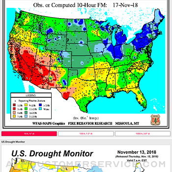
- Fire Potential Index: 7-day Forecast
- Large Fire Probability
- Fire Danger Rating
- Expected Large Fires per PSA
- National Significant Fire Outlook: 4-months
- NFDRS Dead Fuel Moisture
- US Drought Monitor & Index
HAZARDOUS WILDFIRE CONDITION ZONES
- Detailed NOAA discussion
GOES-16 SATELLITE IMAGERY ANIMATIONS
- Regional zones (CONUS)
* Available for iPhone and iPad with single purchase *
Feel free to contact me at [email protected] if you have any questions.
Enjoy.
Wildfire - Fire Map Info App Comments & Reviews
Wildfire - Fire Map Info Positive Reviews
Great resource for national/regional overviewAs the app states, the information provided is not detailed enough for operations; however, it has plenty enough detail for someone to keep tabs and make reasonable estimations of regional fire behavior thanks to the forecasts. I use this app to watch the fire season progress while I’m not deployed. I took one star off because the main map is not quite intuitive. I wish when you clicked on the fires it could give more information about them. Also, it would be nice if the map would indicate where the forecasting offices are for people like me who are unfamiliar with them so I can cross reference forecasts based on stations nearest to the fires. A minor gripe, overall I love the app!.Version: 1.1.5
Awesome supportI saw something I’ve never seen before: the developer actually offering to assist a confused reviewer! I decided to chance it and bought the app. Noticed a small discrepancy and notified the developer, and he responded within the hour with professional curtesy and appreciation! The developer genuinely is concerned about his creation and how people like it and it shows! Concerning the app: fantastic link to NOAA data that is very timely and accurate! We could see the progression of the Pole Fire (Utah) and we could predict that some communities might be under threat, and then the public alerts for evacuations started coming from the local news. On the downside: the map could use a bit more detail regarding terrain, towns, and roads, as we had to translate the maps here with Google Maps to determine scale and location with surface features. How the developer can accomplish this is a bit beyond me, but would welcome to help where I can. Despite this one drawback, I must give this app 5✖️🌠🌟⭐️💫✨!.Version: 1.0.8
Missing DataMy friend's house in Zuma beach is gone as of a few hours ago and several other friends I haven't heard back from about their homes in Malibu, TO, Agoura during the Woolsey fire on November 9, 2018. No data even showing for Malibu when much of it has already been evacuated and burned. I tried the zooming in and out. Yes, of course this app shouldn't be relied upon to save one's life. But it doesn't even show Malibu as a burn area as of 3:45pm when much of the area has already been burned. UPDATE- data seems to be coming in slowly. As of 5pm-ish data for Malibu burn area and Sta. Monica mountains is now showing. UPDATE- Also noticed air quality index isn't accurate either, maybe based on conditions without the fires. About 48 hours into the Woolsey and Hill fires still shows good-moderate all over the area. We are 50mi east of fires in Pasadena and the air out here is thick like burning tires. Can't go outside..Version: 1.0.8
Fantastic app!I’ve been hearing so much about the fires here in AZ I decided to get this app...and how wonderful...gives so much info on every fire in the state! And much much more! I wouldn’t change anything, except I would add state maps showing which roads were closed. I haven’t been here in AZ very long and do not know the state very well...there are a lot of road closures and I have no idea where they are in reference to the big fire. I have a drive coming up on Thursday (Northern AZ to PHX) and I want to avoid the fires if at all possible. Over the weekend I17 was shut down, some say due to fires, others say no just traffic, and that’s the only reasonable route to PHX from the verde valley. Detailed Road maps would be a help. (Sorry so wordy, I am an elderly talkative☺️). Great app... 6 stars!.Version: 1.1.8
Looks promising so farComing from Australia I miss the coordinated fire information available in Victoria, so finding this looks promising. One thing I've noticed is that the area of a fire appears when you start to zoom in but then is lost when you zoom in a bit more. Be nice if it wasn't so you could get a better picture of the extent..Version: 1.1.1
App not updatingClicking on the inciweb tab makes the whole app shut down. Fire data does not appear to be updating. I’ve contacted the developer with no responses correcting the issues. I have noticed that all of the feedback is from a year or more ago. Edit 8/8/23: thanks for the correction. The app is working fine now, and the link to Inciweb is seamless and works nicely..Version: 1.3
Was going to find another app butI was going to look for different app because I hate the view of legend. It was difficult to view map. But as soon I saw your new update information that you have added “hide legend”. I kept the app! 😁Seems you’re the only developer keeping updates on your app. The other apps apparently were over a year old!! 😮 Please keep improving your app!!.Version: 1.1.4
Has PotentialI live in SoCal, and need up-to-date info. Few improvements: 1) slow loading at times and 2) you have a refresh button, but there should be a “time” indicated of when the map was last updated. You can refresh, but it’s possible the data is 5 hours old and the winds/fires have shifted. 3) Download option. I was stuck in an area where the cell towers had been destroyed. A “saved” option that saves to the app so you can see the most recent fire status..Version: 1.1.4
Grateful for the peace of mind provided by this appThis app has been super helpful for tracking the progression of the Kincade Fire in Sonoma County. Thank you for making this information easily available. The ability to hide the legend is great. 2 pieces of feedback: the icons and text on the legend are difficult to make out because of the small size, and it would be nice to have a brief explanation of MODIS and VIIRS in the app..Version: 1.1.4
It’s what Cal Fire recommends so that’s good enough for meWhen talking to a Cal Fire fighter who stopped to check on a fires progress because it was 2 canyons away from our house we were being evacuated,. We wanted the quickest update info onwhere the fire was, how much contained it was we were told to check here. Don’t be caught without it during fire season..Version: 1.1.9
Useful for overall weather & trendsGood technically based analysis - had to get definitions for a few weather abbreviations. I expected to see a few active NorCal fires showing on map, but did not. Maybe they’re no longer burning? Or maybe I need to learn to use this app..Version: 1.1.19
Great developer support, interface is imperfectCrazy good developer support for a 99¢ app! I emailed the developer to report a bug and make a small feature request. Not only did he respond quickly, he pushed out an update fixing and implementing both within a couple days!.Version: 1.1.4
A must for fire prone areas of the country.I’ve been glued to the Bobcat fire updates on the app for a week. Watching the glow get brighter and my area get smokier. This a great app. The details of where the fire was moving were informative. I didn’t have to wait for updates on TV. I highly recommend the app..Version: 1.1.14
Great appAside for a few minor tweaks, I find this a very useful app. Highly recommend. Update- developer offers awesome support of the app. I received a very quick response in answer to my emailed questions/comments. ‘Wildfire’ app continues to inform me well, especially this fire season here in California..Version: 1.1.4
MapHello, I enjoy the map it is a cool map. The first map that you go to, I wish that you could see the fires, or what is that?Dunno what it is. The Inciweb Fires, there should be an area on the side after your touch it and you do not go to the website..Version: 1.1.14
Incredibly helpful app!We are currently surrounded by wild fires and this app gives you all the updated map information and fire information to include evacuations. The app acquires its information and includes links to national agency’s on wild fires..Version: 1.1.8
Everything you need to track wildfiresWildfires are sadly becoming a common fact of life in the age of climate change. I use this app to help track where they are..Version: 1.1.4
Legend covers half the screen!Nice app w/lots of info, but on iPhone 8 the legend practically covers half the screen on the active wildfire view. Need a drawer to hide it and actually see the map..Version: 1.1.1
AccurateWith the SAT pictures, I think this app has deadly good precision at locating fires and for how long. Works best around WiFi just because there is so much information to be downloaded..Version: 1.0.8
App is awesome again!The last update fixed everything.....Thank You!.Version: 1.1.13
Instructions?This site is hard to figure out. I can see there’s a fire near me but can’t get any useful information..Version: 1.1.1
WildFire AppA very useful app so the development team should be pleased as this is a very useful tool in keeping up to date with Wildfires..Version: 1.1.4
BasicNice UI. Easy to use. Provides only very basic info. I wish it had alert and evacuation zones mapped. That would make it useful enough to keep on my phone..Version: 1.1.8
Fixed crashing issue . . .Restarted phone and switched to LTE and now app is working on both WIFI and LTE. Nice app!.Version: 1.1.1
Useful app, but really slow to loadUseful app, but really slow to load.Version: 1.0.11
Very informative appVery informative app for finding fire maps..Version: 1.0.10
Easy to use!This is a great app for keeping track of the wild fires!.Version: 1.1.9
WowFabulous to get so many options to view the world in layers of wind&moisture&heat.Version: 1.1.11
Smoke viewGood satellite view of where the smoke is..Version: 1.1.14
Can be usefulA useful resource. A bit for the professional who understands the terminology used because there’s no glossary..Version: 1.1.13
NOAA is a US government agency...Education is the answer. Try some..Version: 1.1.1
Free International Money Transfer 💸Enjoy high maximum transfers into more than 20 currencies while saving up to 90% over local banks! The cheap, fast way to send money abroad. Free transfer up to 500 USD!Version: 1.3
What do you think Wildfire - Fire Map Info ios app? Can you share your thoughts and app experiences with other peoples?
Please wait! Facebook comments loading...


-logo.jpg)
