Bist LLC
Marine Navigation-USA Lake Map Customer Service

- Marine Navigation-USA Lake Map Customer Service
- Marine Navigation-USA Lake Map App Comments & Reviews (2026)
- Marine Navigation-USA Lake Map iPhone Images
- Marine Navigation-USA Lake Map iPad Images
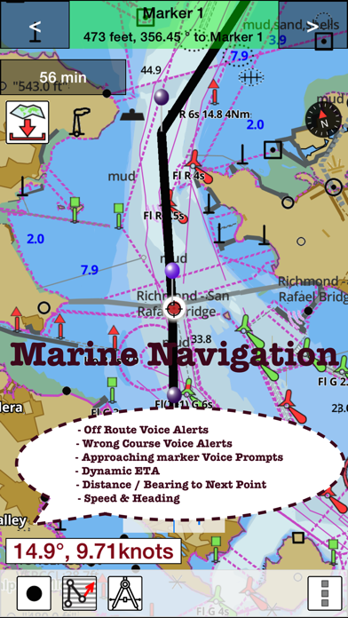
Marine Navigation App offers access to NOAA marine vector charts, freshwater lake maps, USACE inland river maps. Only marine GPS app to have route assistance with Voice Prompts for marine navigation. It has route manager to create new boating routes or import existing GPX/KML routes. It supports Nautical Charts course up orientation. Includes Tide & Currents prediction.
* Hardware/GPU accelarated vector charts (text stays upright on rotation).
* Voice Prompts for marine navigation (requires GPS )
* 1ft / 3ft depth contour maps for anglers for selected lake maps.
* Supports GPX/KML for boating route editing/import.
* Tide & Currents prediction.
* Seamless chart quilting of marine charts
* Enter way points
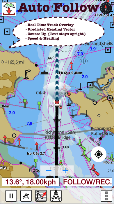
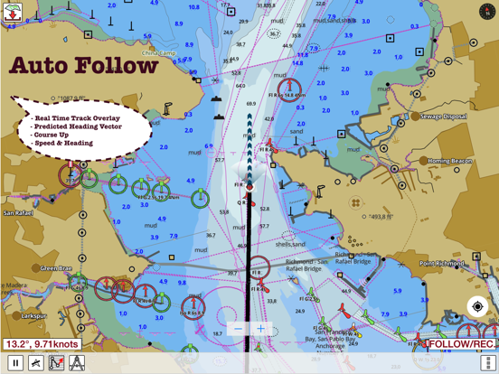
* Record tracks, Autofollow with realtime track overlay
* Voice Prompts for marine navigation (requires GPS )
-prompts when approaching a boating route marker
-Continous distance and ETA updates
-Alerts when sailing/boating off route
-Alerts when boating in wrong direction
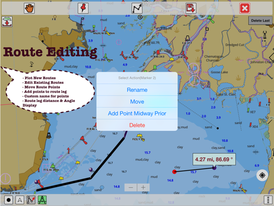
*Route Editing/Creation
-Create routes from scratch
-Edit existing GPX/KML routes.
-Add custom description to any route point.
-Drop markers along route.
* Offline NOAA marine, lake & river charts
-Visually download using grid
-Textual search
* Tide & Currents
- High / Low tides.
- Tidal Currents.
- Active currents stations.
*Seamless chart quilting of marine charts
*Distance Bearing tool
*Create custom way points
- Using GPS
-Select point on map
-Manually enter latitude & longitude coordinates
*Pan/Zoom/My Location
* Record Marine GPS tracks
* View tracks overlay
* Live track animation
* Track analytics/stats
* Export GPX trcks.
-Export to SDCard
-Share GPX tracks with friends.
* Auto Follow Mode (Course up)
-Continuously updates boat's location on chart
- Adjustable update frequency
Sample Nautical Charts (please visit http://gpsnauticalcharts.com/main/folio-catalog-nautical-charts-app for complete list)
SUGARLOAF KEY-KEY WEST
PORT RICHEY TAMPA BAY - CLEARWATER HBR
EAST BAY-WEST BAY FLORIDA
ST JOSEPH, ST ANDREW BAYS
INTRACOASTAL WATERWAY MATECUMBE-GRASSY KEY
CHESAPEAKE BAY CAPE CHARLES-NORFOLK HARBOR
ANCLOTE KEYS-CRYSTAL RIVER
ST JOSEPH SOUND
MIAMI HARBOR
Minnesota lakes - Kabetogama, Minnetonka, Waconia,Leech,Mille Lacs
Lake Keowee,Jocassee,Hartwell,Greenwood,Lake Murray
Mark Twain,Ozarks,Table Rock
Lake St. Clair
Lake Kentucky
KEY WEST-THE MISSISSIPPI RIVER
SAN PEDRO CHANNEL
LAKE MICHIGAN STONY LAKE-POINT BETSIE
APALACHICOLA BAY-CAPE SAN BLAS
EAST CAPE-MORMON KEY
CAPE HENLOPEN-INDIAN RIVER INLET
CHESAPEAKE BAY CAPE HENRY-THIMBLE SHOAL LIGHT
DULUTH-SUPERIOR HARBOR
MONHEGAN ISLAND-CAPE ELIZABETH
LAKE ONTARIO - CLAYTON-FALSE DUCKS ISL
Lake Winnipesaukee
SAN FRANCISCO ENTRANCE
MIAMI-MARATHON, FLORIDA BAY
CAPE MAY-FENWICK ISLAND
MISSISSIPPI RIVER-GALVESTON
CAPE CANAVERAL-KEY WEST
DELAWARE RIVER WILMINGTON-PHILADELPHIA
FLORIDA KEYS SOMBRERO KEY-SAND KEY
SAN PABLO BAY
RAINY LAKE BIG ISLAND MINN-OAKPOINT ISL ONT
INTRACOASTAL WATERWAY - BISCAYNE BAY
EVERGLADES NTL PARK - SHARK RVR-LOSTMANS RVR
MIAMI-MARATHON & FLORIDA BAY
BLACKBURN BAY
LAKE HURON
LAKE TAHOE
STRAITS OF MACKINAC
NORFOLK HARBOR & ELIZABETH RIVER
SAN DIEGO-SANTA ROSA ISLAND
DELAWARE BAY
CHOPTANK RIVER CAMBRIDGE-GREENSBORO
FORT LAUDERDALE PORT EVERGLADES
ST SIMONS SOUND-TOLOMATO RIVER
CHESAPEAKE DELAWARE CANAL
CAPE MENDOCINO
STRAIT OF JUAN DE FUCA ENTRANCE
PORT RICHEY CLEARWATER HBR
PAMPANO BEACH-HALLADALE FLORIDA
LAKE ERIE
LAKE MICHIGAN INCLUDING GREEN BAY
MAIMI-MARATHON and FLORIDA BAY
SANTA CATALINA ISLAND
APALACHICOLA BAY-LAKE WIMICO
Battery Disclaimer:
"Continued use of GPS running in the background can dramatically decrease battery life."
Marine Navigation-USA Lake Map App Comments & Reviews
Marine Navigation-USA Lake Map Positive Reviews
Great app for iPhone but...Does not have all the features on iPad. Especially lacking is the "follow" feature which is the highlight of this app imho. Works great on phone though. The vector chart for the northeast seems to be a little off. At least on my iPhone and iPad it is always about 30-50 feet off from reality. Not an issue in open water naturally but when you're in a tight channel it can be a little nerve racking. Not a bad app all and all though..Version: 58.0.0
Novice navigatorThis app is full featured and remarkably we'll documented. The only thing I couldn't figure out was explained well and promptly by support. I think this app is great! I would benefit from availability of even more maps..Version: 22.0.0
Great buyGreat app. Using it right now on my travel down the Chesapeake. Has speed, depth and I can download tons of noaa charts without additional charge that are accessible offline. Also one thing I like is to place a waypoint when I anchor. In the night if I am worried I am drifting I check this app to see where my gps is versus the anchor. That is super useful in my book..Version: 58.0.0
CrashingHave had this app since 2013 use it a lot as a back up GPS even 60+ miles offshore fishing. It’s very accurate. However, recently started “crashing” a lot after a few minutes of use. Please fix the bug..Version: 58.0.0
Downloaded and used on a recent trip to the FL KeysVery useful in guiding through the keys channels. Once you have a map and want to plot a route this is very useful. Takes a little getting used to but got the job done. Harder to use on iPhone due to screen size..Version: 58.0.0
Great supportThe support for this app is amazing. You get a response right away and it's always helpful. As a non technical person I'm delighted to have great support..Version: 58.0.0
I can't believe how much I use this appICW night navigation made easy. Thank you for the assistance..Version: 58.0.0
Great app! Better than my Garman.Great app.Version: 58.0.0
US Nautical Charts-NOAA-Marine Charts app for sailing boating kayaking and fishing - USAI hold a 50 ton inland Masters license and am a professional mariner in the San Francisco Bay Area. I have used many professional GPS based electronic navigation applications both on dedicated hardware devices and PC based applications such as Navtrek from Nobeltec Software. I recently downloaded GPS Nautical Charts on my iPhone while on vacation in Maui, Hawaii. I was very impressed with how easy it was for me to download the charts for the regions I wanted as well as the ease of use for all the functions, i.e. location indication based on the iPhone's GPS, route planning, track, way points etc. I liked this program so much that tomorrow I'm buying an iPad with 3G/LTE connectivity that has the built in GPS sensor. I plan to install this software on my new iPad and use it on the bay where I crew on the local charter sailboat NEHEMIAH. Also the customer support has been outstanding. All my questions asked via email were answered immediately and provided complete solutions to any issues I had. Anyone who has experience with any of the existing dedicated hardware or PC based electronic navigation software will be very impressed with US Nautical Charts-NOAA-Marine Carts app for sailing boating kayaking and fishing - USA! I just purchased the iPad and installed US Nautical Charts-NOAA-Marine Charts app for sailing boating kayaking and fishing - USA on the iPad as well and am very happy with the details of the chart images, the functions and the user support. While this app. for the iPad is identical to the iPhone app., the larger platform makes it quite a bit easier to operate. One additional note: I've read some of the negative reviews of this app and am quite baffled by the negativity. While I can't compare it to other iPad or iPhone apps., I think this app performs quite well especially when I remember that just a few years ago I needed a PC, Garmin or other brand GPS along with the software like Nobeltek to do the same tasks. Also, connecting the GPS to the PC required a special interface. Unless one is a power user who needs distance off, radar & weather overlays etc. this is a great app..Version: 11.0
Very handy appI was down in West Coast Florida on a vacation and decided to rent a boat for a few days. Didn't really know my way around so I took a chance on this app and it turned out to be much better than expected. I was able to plot a course the night before to a likely looking redfish hole and really got into them the next day. Love the auto track feature. It shows an arrow on the screen that shows where you are headed. I used it on my phone that day but since then I have installed on my iPad..Version: 23.0.0
Like the updatesI had this app on my Sony Xperia before I got an iPhone. Setting up on iPhone was a lot easier since I didn't have to plot routes again. I was able to transfer all my routes from Xperia to this one. They are very responsive to feedback. I had asked them to add lake Sammamish over a month back. And today I was able to get a bathy chart for this lake and I can see they have added almost every popular lake around my area. I am very pleased with this level of app support..Version: 14.0.0
Texas lakesI tried almost every lake app out there. This is the only one I found that offered comprehensive coverage for inland Texas lake maps. I have been using it for quite some time now. It has worked flawlessly for me. The maps are quite detailed, and I like the way app shows the route I am taking - much better than my garmin. I was even able to hear the sound guidance on my portable Bluetooth device..Version: 11.0
Captain RobThis is the most useful app I have ever used for navigation. Waypoints, distance, and record and auto follow work great! Then go back and see exactly where you've been and your speed throughout! Highly accurate charts and charts for all you needs. I have it both on my iPhone and iPad. Handheld GPS for those foggy days can't be beat anywhere for the price! Highly recommended!.Version: 23.0.0
Decent appI got the impression from the app description that you could see a map that simultaneously provides all of the data that's provided by the app -- location, depth, current tide and tide forecast. Unfortunately, it's not the case. However, it does have the info you need -- it just takes a little bit of navigating through the app and head-math to get to it..Version: 22.0.0
Route ManagerI was able to transfer all my existing routes from my PC route planning software to this. I am glad it did not loose the names of points i had so meticulously entered. Looking forward to using it this summer..Version: 10.0
Decent appHard to figure out at first. Once you figure it out it is very useful..Version: 21.0.0
AccuracyI like the accuracy of my GPS location on the map..Version: 23.0.0
Precise route plottingI like how easy it is to plot precise routes using this app. Finally an app that gets it right..Version: 10.0
Great appPerfect app with perfect precision.. Now I don't have to use those clunky devices this summer. Love it...Version: 10.0
Replace your plotterGreat app for boaters and sailors. I use it on the phone and on my IPad..Version: 23.0.0
CleanVery clean, nice features, easy. Good job!.Version: 22.0.0
MrWorks great for me..Version: 19.0.0
Free International Money Transfer 💸Enjoy high maximum transfers into more than 20 currencies while saving up to 90% over local banks! The cheap, fast way to send money abroad. Free transfer up to 500 USD!Version: 150.0.0