This App offers access to Marine Charts for USA,Canada,UK/Ireland,Germany,Netherlands/Holland &
Europe Rivers (Danube,Drava,Rhein etc). Coverage includes NOAA marine vector
charts,freshwater lake maps,USACE inland river maps (HD/1ft/3ft bathymetry
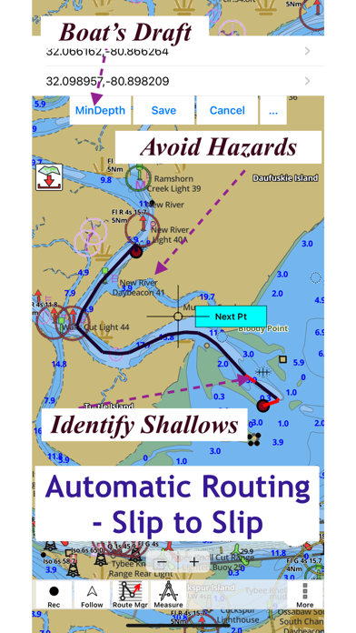
included where available),charts derived from UKHO & CHS data. First marine GPS app to have route assistance with Voice Prompts for marine navigation. You can create new boating routes or import existing GPX/KML routes. It supports Nautical Charts course up orientation. Includes Tide & Currents prediction.
►FEATURES
√ Beautiful & detailed Hardware/GPU accelerated vector charts (text stays upright on rotation)
√ Long press to query the details of Marine object (Buoy,Lights,Obstruction etc).
√ Customizable depth(Ft/Fathom/Meter) & distance units(km/mi/NM)
√ Customizable Shallow Depth.
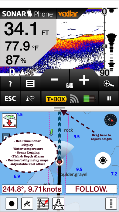
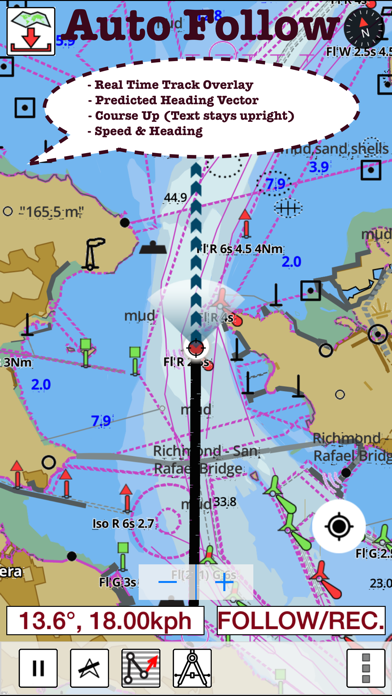
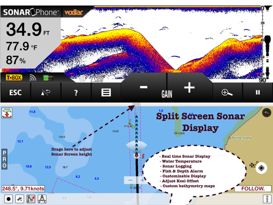
√ Record tracks,Autofollow with real-time track overlay & predicted path vector.
√ Voice Prompts for marine navigation (requires GPS )
√ 1ft / 3ft depth contour maps for anglers for selected lake maps.
√ Supports GPX/KML for boating route editing/import.
√ Tide & Currents prediction.
√ Seamless chart quilting of marine charts
√ Enter or import Waypoints.
► MAPS
It includes unlimited updates for 1 year.
√USA: The maps include coverage of all NOAA marine vector charts (ENC),USACE inland river maps,freshwater lake maps for more than 7K lakes. The charts include HD/1ft/3ft bathymetry where available.Incl. NOAA raster where ENC not available.
√Canada:Incl. CHS data(incl. major Lakes).
√UK/Ireland: Derived from UKHO charts.
√Australia
√Germany: derived from BSH data
√Europe Inland Rivers:Donau/Dunaja,Rhine,Garonne,Moselle,Drava,Sava,etc
√Norway
√Finland
√Sweden
√Croatia
√Ukraine(Black Sea)
√Caribbean
√New Zealand
√Spain
√Brazil
√Argentina
√Cyprus
√Falklands
√Seychelles& Mauritius
√Denmark
√Malta,Cyprus & S. Mediterranean
√S. China&Malaysia
√South Africa
►ROUTE MANAGEMENT / TRIP PLANNING
√ Create New Route/Edit Existing Routes
√ Move Points
√ Add points to an existing route leg
√ Delete / Rename points
√ Import GPX,KML & KMZ files
√ Plot/Edit Routes
√ Enter Waypoints
√ Share/Export Routes,Tracks&Markers
√ Reverse Routes
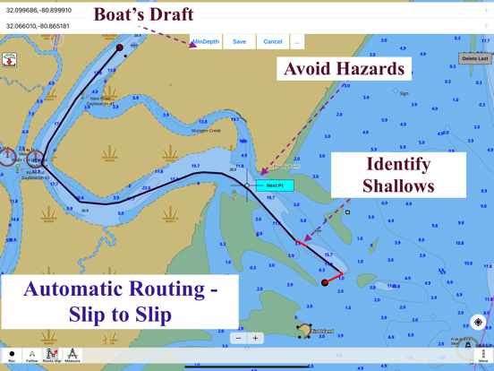
►SLIP TO SLIP AUTO ROUTING
►GPS FEATURES
√ Auto Follow
* Real Time Track Overlay
* Predicted Path Vector
* Course Up(Text stays upright)
* Speed & Heading
√ Route Assistance With Voice Prompts
* Prompts when approaching a boating route marker
* Continous distance & ETA updates
* Alerts when sailing/boating off route
* Alerts when boating in wrong direction
√ Record Tracks
►TIDE & CURRENTS
* For US,Canada,UK,Germany & New Zealand
* High/Low Tides
* Tidal Current Prediction
* Active Current Stations
►Instrumentation
√ Marine AIS & (NMEA AIS and GPS over TCP/UDP)
√ Wind direction & Speed,Marine Sonar depth,Water temperature
√ Auto Pilot
► SHARING
* Share tracks/routes/markers on Facebook & Twitter
* Export tracks/routes/markers as GPX files.
SUGARLOAF KEY-KEY WEST
PORT RICHEY TAMPA BAY - CLEARWATER HBR
EAST BAY-WEST BAY FLORIDA
INTRACOASTAL WATERWAY MATECUMBE-GRASSY KEY
CHESAPEAKE BAY CAPE CHARLES-NORFOLK HARBOR
ANCLOTE KEYS-CRYSTAL RIVER
ST JOSEPH SOUND
MIAMI HARBOR
Minnesota lakes - Kabetogama,Minnetonka,Waconia,Leech,Mille Lacs
Lake Keowee,Jocassee,Hartwell,Greenwood,Lake Murray
Mark Twain,Ozarks,Table Rock
Lake St.Clair
Lake Kentucky
KEY WEST-THE MISSISSIPPI RIVER
SAN PEDRO CHANNEL
LAKE MICHIGAN STONY LAKE-POINT BETSIE
APALACHICOLA BAY-CAPE SAN BLAS
EAST CAPE-MORMON KEY
CAPE HENLOPEN-INDIAN RIVER
CHESAPEAKE BAY CAPE HENRY-THIMBLE SHOAL
DULUTH-SUPERIOR
MONHEGAN ISLAND-CAPE ELIZABETH
ONTARIO - CLAYTON-FALSE DUCKS
Winnipesaukee
MIAMI-MARATHON,FLORIDA
CAPE MAY-FENWICK ISLAND
MISSISSIPPI RIVER-GALVESTON
CAPE CANAVERAL-KEY
DELAWARE RIVER WILMINGTON-PHILADELPHIA
FLORIDA KEYS SOMBRERO KEY-SAND KEY
SAN PABLO BAY
RAINY LAKE BIG ISLAND MINN-OAKPOINT
INTRACOASTAL WATERWAY-BISCAYNE BAY
EVERGLADES NTL PARK
HURON
TAHOE
CHESAPEAKE DELAWARE CANAL
BACKGROUND GPS CAN DECREASE BATTERY LIFE
I-Boating: Marine Charts & Gps Positive Reviews
Good appPretty good overall, sometimes GPS doesn’t work the best.Normski92Version: 165.0.0
Good app.Seems good so far..Ez2plzme2niteVersion: 71.0.0
Accurate and detailedThe app is easy to read, completely accurate, detailed and FREE!!!
Well the basic app is free. I will probably be buying the full version depending on how much time off I can get from my business to go boating.BradleyabroadVersion: 159.0.0
Great app, and great offlineUsed this app on Lake Opeongo, very accurate and great when using offline. I wish there were more lake in Algonquin Park.
Great for Lake Opeongo, Canoe and Smoke in the park.Braden F.Version: 155.0.0
SailingThis app is great O have it on my phone and Tablet but my tablet is saying that I need a new update but I did it a few months ago could be a scam!!!.Savings lotsVersion: 155.0.0
BestNeed contours or a fishing chart.QaaminaVersion: 172.0.0
Connection satellite et localisationParfois j’aurais besoin de reconnecter et donner aceces à la localisation ds mon iPhone
Un menant bouton directement à cette fonction serait très pratique et plus sécuritaire
Merci.DalamdilidouVersion: 171.0.0
Best Navionics Ontario appAfter Garmin raised the prices of their Navionics app, I tried virtually every charting app on the store. This is the best I’ve found. It’s the only one that includes detailed depth contour topo maps for Ontario lakes. Navionics costs more than twice the price of this one and does not include details for these lakes. This one is a hidden gem.
Will update more as I continue to play with it.
The developer added Dollar lake depth contours using the survey soundings I provided. Appreciate the support.
The app has a hidden feature that lets you increase the size of icons and fonts. Very useful for far sighted people.
Going ice fishing later this season. Will post more updates on that. Used it at Minnetonka. Worked well..Fish n Boat CompanyVersion: 168.0.0
Need HelpI have emailed support 3 times, can someone please respond..Labradorkid71Version: 167.0.0
Can’t do better for freeVery good and actually free maps.PumpkinheeeedVersion: 159.0.0
A bit pricyCould do more pretty basic.HalspaceVersion: 159.0.0
CoordinatesI like that app just fairly expensive for the usage I get out of it. Great when trying out new lakes..Muny$21Version: 159.0.0
Great definitionWe really appreciate the shading that gives definition to depth readings!.A Woodland OasisVersion: 157.0.0
Free International Money Transfer 💸Enjoy high maximum transfers into more than 20 currencies while saving up to 90% over local banks! The cheap, fast way to send money abroad. Free transfer up to 500 USD!AdvertorialVersion: 172.0.0
I-Boating: Marine Charts & Gps Negative Reviews
Won’t money give u first bit for free then try to tempt you with a new version for cash crooksRip off.WopooseVersion: 131.0.0
In app purchases expireBuy charts in the app and they expire rendering the app useless unless you continue LT upgrade at $34.99 a pop. Slimy business practices..Kelly.46645678653246Version: 125.0.0
Pay every yearI don’t like paying every year for charts I already purchased. No thanks !.MintdipVersion: 124.0.0
Unable to restoreI purchased previous Canada maps but upgraded my phone and now it won’t restore or update and won’t work without a update. Really not impressed.YahooUser1234Version: 124.0.0
Need to buy the map every year !?!?Keeps asking me to purchase the same map I already purchased last year for 40$.HjhjfhjfjhfjhfVersion: 122.0.0
InaccurateThe majority of lakes on here are dead wrong when it ones to depths. Pretty much useless other then the countries are semi accurate.Johnschatz1Version: 111.0.0
Not restoring purchasesGood app but Bought Canada and USA last year and they’re not letting me restore. I’ve emailed twice. Two weeks and no response..Vorker42Version: 110.0.0
Just purchasedNot that easy to use would like my money back.Bigs & JaxVersion: 110.0.0
Rip offAnytime update or get bew phone can’t re install purchases have to rebuy them, also the charts arent even close to accurate for the the lake actually is.Cupper444Version: 173.0.0
Purchased map goneI bought maps in my area last summer. Now it’s gone. “Restore” button doesn’t work. No response from the developer for weeks either. I want my money back..Dinky lanternVersion: 173.0.0
Waste of moneyI paid 45$ for a map for my area last summer. Now it’s gone and the apps asking me too upgrade again. I will not be doing so. Give me my map back!.BCnugzVersion: 172.0.0
AI fishing not workingAI fishing not working.KevinkevinnnnnnVersion: 171.0.0
Boating appThere isn’t enough information on using it it doesn’t tell me where I am on a lake..Mr. ChupsVersion: 169.0.0
LocationI have reloaded maps twice and always shows my spot but it’s easily 200-300 meters away from where I really am..Highlander705Version: 169.0.0
Too expensiveWorks super well then after a few days they disable gps and you have to pay way too much money to use it.NSNSNS RepresentVersion: 169.0.0
Not happySaid it had great slave lake in the Canada maps so purchased for 40 dollars to find out there were no depth charts for that lake still waiting for my refund.Kylep509Version: 168.0.0
Gps locationIt is so inaccurate. This app is almost useless.Link1234567891011Version: 168.0.0
SlowApp takes to long to locate where you are.Money3366Version: 167.0.0
Lacking a lot of lakesWas disappointed to see how many lakes are missing from the maps.Shed head 6mmVersion: 167.0.0
Really infuriatingGood for the most part until you try find a certain lake and it put some kind of message on top of the one lake I want to see with no way of getting rid of also the only app that has that lake.SfjuvVersion: 167.0.0
Good Info but UglyFirst of all, the app has good information in it, but all the good things end there because it’s a UI nightmare. It’s not user friendly and easy to read. And man it’s hideous to look at. It looks like the graphics have not been updated since the year 2000. Please hire a graphic designer and make it easier to read and use. And what’s up with the tidal chart? There are 5 segments for 4 hours making it 48 minutes per segment?! What and why? Who does that? And the time on the x axis is set to whenever you open the chart and not full hours like a normal person would expect. So if you open the chart at 16:37, that’s your reference time and all other time on the chart will be derived from there. C’mon!.DachinnoVersion: 167.0.0
Scam*** this App is a scam***
you pay for Canada US maps then after a year you cannot download old maps and they want to you to pay for new version of maps. Total scam because we should be allowed to download old maps we paid for. It says in their app the maps you download are for lifetime (I don’t want to upgrade each year but no way to keep old maps).DaTrueNorthVersion: 167.0.0
Map Overlay InaccuracyMap overlays can be off as much as 200-300 meters. Not very helpful when there are shoals in the lake which you are trying to avoid. Customer support is horrible and only available through email, which they don’t answer - there is no phone #, and no one to dissolve issues with. I asked for a refund - crickets. Not recommended at all. Go with a different app..In the rough!Version: 160.0.0
Purchased map and disappeared after a year.Purchased a map and won’t restore. They shouldn’t expire..Copernicus2319Version: 160.0.0
Not what I expected when paying 40$Paid 40$ for ocean bottom but when I zoom in it gets foggy and can’t see , fix asap.Wolf736Version: 160.0.0
Horrible appHorrible maps, completely inaccurate. Said I had 36 feet, but there was only probably about 3 feet. Hit a rock and damaged my prop. I just downloaded this app today and already has done me wrong. I WANT MY MONEY BACK.Manitoba boaterVersion: 160.0.0
Do not pay for this appJust wasted $40. It didn’t work when I needed it the most, boating backcountry. I was left crossing my fingers and shaking my head that I didn’t listen to other reviews stating the same thing..Don’t by appVersion: 160.0.0
Crashing all the time...I purchased this app last year. It worked for one fishing trip. I did the in app purchase of the Canada and USA marine charts for $39.19. Now the app crashes on startup. I updated the app, I followed the troubleshooting instructions provided by Apple. I tried to contact the app developer - Bist LLC via email multiple times but never received a response. I sent them a video of the apps behavior but that went unheeded as well.
I am disappointed as this held a relatively inexpensive option for us tin boaters who don’t have the real estate for a proper chart plotter.
It is bad enough that the app doesn’t work, but silence from the developer leads me to think they are advertising a product that is misleading in its operability..Changed my life 2Version: 160.0.0
MapsSo hard to bring up the location, not user friendly. Every move asking for more money. Not satisfied with what I paid for..Redub2022Version: 160.0.0
DenisJe ne suis pas capable d’avoir ma position..DennnnnnisssssVersion: 160.0.0
ExpensiveI bought the app so that I could use all the features. It was supposed to be a one time purchase, but one year later I can’t use all the maps I downloaded unless I update to the latest version and to do that I have to buy the app full price again. In the end it was a rip off. I emailed them several times but they have never responded.Xcski89Version: 159.0.0
Charged twice!!Purchased the Canada map and I was charged twice for it!! No support offered when I reached out- and apple won’t refund me for the 2nd charge! Apple does not have the customers back on the App Store!!.Kat92!;6Version: 159.0.0
One-time purchase is a lieWorked for less than a year before dropping my subscription and locking me out without re-purchasing..LummooseVersion: 159.0.0
HelpWhy does the app say it’s 39.99 and on the webpage is says 24.99. If we’re the lower price I would purchase. Also is this a one time fee or an annual charge??.Wet ěVersion: 158.0.0
Maps are not accurateI was going to get a full membership but used the app on the water and it was 70% wrong. It said 70 feet deep but was 3 feet. It had some details correct but useless for planning a day of fishing..Crash2!Version: 154.0.0
GPS and map problemsI use the app for the first time today, and the GPS location was over 30 yards out. I’m using a brand new iPad Air 6 cellular. I switched to my other mapping app and the GPS location was perfect. Is this fixable?.DMG422Version: 155.0.0
Do not buyAfter year app stopped working
And constantly prompting to get update for $39
After spending $80 for this app on 2 devices it is just waste of money
Sent email to support and no one bother to answer.$@@?/Version: 154.0.0
Payoneer 💰Payoneer is an online payment platform that lets you transfer money from any corner of the world! A best and must have payment service for every blogger, traveler, freelancer, affiliate marketer, consultant, virtual assistant, business person, online sellers, and receivers. Earn $25 for free by joining Payoneer. Sign Up Now!AdvertorialVersion: 172.0.0
 Bist LLC