Iterum, LLC
Wasatch Backcountry Skiing Map Customer Service

- Wasatch Backcountry Skiing Map Customer Service
- Wasatch Backcountry Skiing Map App Comments & Reviews (2026)
- Wasatch Backcountry Skiing Map iPhone Images
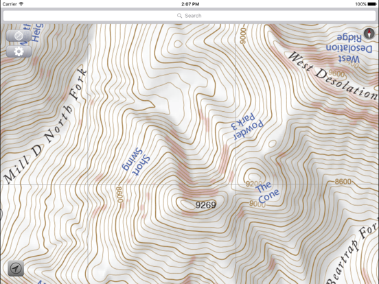
- Wasatch Backcountry Skiing Map iPad Images
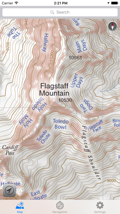
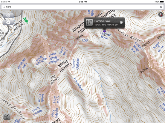
The Wasatch Backcountry Skiing Map is the iOS version of the popular paper map and website (visit WBSkiing.com). As with the other platforms, the iOS map includes an index to more than 1,000 backcountry locations in Utah’s Central Wasatch mountains. It is the must-have app for Utah hikers and backcountry travelers.
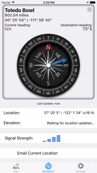
With a familiar map-app interface, the Wasatch Backcountry Skiing Map accesses your device’s GPS to display your current location on a high-resolution topo map. And with only a few taps, the “destination arrow” on the integrated compass will point to your desired backcountry ski location.
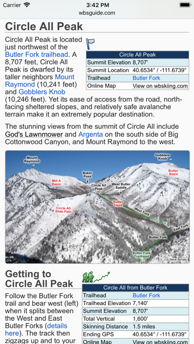
And with a single tap, hundreds of the locations will open the Wasatch Backcountry Skiing Guide website where you can view photographs and detailed information about the location.
The app also displays your current elevation and lat/long, and will send your current location via email. And with a tap, you can display detailed information on more than 200 of the locations including skiing difficulty, skinning distance, vertical climb, parking considerations, and more.
(Contrary to a posted review, you don't need cell service to use this app--you don't even need a contract with a cell service provider.)
NOTICES: When navigating, the “destination arrow” points directly to the destination without regard to hazards such as avalanche paths, cliffs, and rock fall. It is your responsibility to travel in the backcountry safely.
Wasatch Backcountry Skiing Map App Comments & Reviews
Wasatch Backcountry Skiing Map Positive Reviews
Absolutely necessary for any Wasatch tourThis app is worth every dime. I always have the paper map in my pack (buy that, too), but to say that I use this app a lot is an understatement. The map and guide are easily the best and most detailed resource available for travel in our mountains. It’s a straightforward PDF of the paper map, but that’s all you need. There’s a compass screen that provides heading, location, and elevation, but that’s about it. No fancy trackers or social media connection to bloat the app and drain your battery. Perfection! I do wish that the online guide were somehow available for download for situations in which you want to research a new line because of a change in plans but don’t have solid signal. I understand that keeping the guide online allows for easier updating, but it would be nice if offline access could somehow be incorporated. As it is, I just screencap every possible entry along any planned route before we leave home. The only other feature I can think of that I MIGHT want is for the option to automatically orient the app to your direction of travel. It lets you do this manually and already has the compass display, so this seems like it might be a simple tweak to connect the two elements. But this is a minor thing, and I don’t think I’ve ever sat on a mountain and really wished it could do this..Version: 3.5.0
A Wasatch essentialSuper happy with this app, and we’ll worth the price. GPS location even when out of service is accurate, and the map is easy to navigate. Elevation is also accurate enough. As others have mentioned, it would be nice to be able to access (offline) info for a specific route that you’re doing that day. It would also be interesting to see an overlay of the route you took (or are supposed to take) for certain routes, although the argument could be made that this takes the learning out of route finding and navigation (fair). All in all, I love it! The extra features would be icing on the cake. I appreciate the work that went into this!.Version: 3.5.0
Don’t tour in the wasatch without this app!I use this app to plan if not to navigate on every tour I go on in the Wasatch. It’s simple to use, accurate, and helps me and my ski partners make good decisions in the Backcountry when exploring new or unfamiliar terrain. It’s well worth the money and should go side by side the UAC app if you’re planning on touring the wasatch area. Less complicated than Gaia, but with enough extras to be a powerful tool in your pocket when you’re on the skin track. Pro tip: You can use it while your phone is in airplane mode ;).Version: 3.5.0
Must have for Wasatch BackcountryReally amazing app. Must have if you plan to go into the backcountry. Useful for planning routes, looking at what’s ahead, and reflecting after. Really great app for being prepared and knowing what’s out there. One thing I always do too is screenshot the area I toured and using the drawing feature in my camera roll I try to map out the runs, tours, and areas I stopped. Well worth the money. Have fun and stay safe!.Version: 3.5.0
Very usefulA friend convinced me to buy this app. I'm happy that I did. It is very useful for route finding especially in places that I am not familiar with. Some of the names on certain lines seem different than what I've heard in the past but not a big deal. Could be helpful in a rescue situation by sending a screenshot of your location (assuming you have service)..Version: 3.0.1
See map, names and position even without a signal.This app is very well done. Significant research went into this. This is most obvious from the free desktop app which is also worth checking out. If you want a great, searchable map of the Wasatch that will show your location even when Google can't, this is the app to get..Version: 3.0.1
Great, changed the face of skiing hereKnowing what the heck the Avy Report was talking about was a breakthrough when this came out. They still manage to name drop obscure places not on the map though- so updating more names would be great. Would also be nice to expand coverage of the map further south to Timpanogos and Provo areas..Version: 3.5.0
FantasticGreat app for skiing Wasatch backcountry. For those moaning about the fact it does not contain every skin track, trail name, switchback and first descent party I say create your own app and ski more to learn about those things. Not everything is served to you on a silver platter; try exploring a little bit instead of complaining..Version: 3.5.0
Pricey, but worth it.I have used this app more times than I can count while touring. The interface is super simple to use, and you don't need a internet connection to use the map. Whether you are skiing, snowshoeing, or snowmobiling, you need this app if you are in the Wasatch backcountry..Version: 3.0.1
Use it every timeI use this app every time I go in the backcountry, whether it's to find the name of a chute on the side of LCC as we're driving up, or to find how far I am from my current objective. It's worth the price if you frequent the Wasatch backcountry.Version: 3.0.1
Must haveFor the central wasatch there is no greater tool. Sometimes worth double checking slope angles as roll overs etc can get lost between the lines.Version: 3.5.0
Update to stop crashingThere needs to be an update, this app keeps crashing every time I try to open it. Phone has been restarted and still having this problem..Version: 3.5.0
10 out 5 starsIf you backcountry,sidecountry,cross country, or downhill ski in in the Wasatch, this app is soooo worth the $$. I even use it hiking! Indispensable knowledge and access to a common language in this mountain range..Version: 3.5.0
So sickI use this app to get pitted. But also to stay safe. Slaying gnar and surviving to slay hot and readys from Little Caesars is the name of the game, and this app helps you win. That and avalanche certification..Version: 3.5.0
Great App!I use this app all the time, and I know this range pretty well. It is a crucial tool if you spend any time touring in the central Wasatch!.Version: 3.5.0
Good for WasatchI really like the interaction and easy to find slide info (names of areas). I wish it covered more of Northern Utah, but great for what it is..Version: 3.5.0
Worth the money.I use it every time I'm in the Wasatch. Wish they would expand to northern Wasatch..Version: 3.0.1
Fantastic ToolWorth every fraction of a cent. This app is an invaluable resource in the backcountry..Version: 3.5.0
Good app but misleading titleThis app is convenient for trip planning, but it does not cover the whole wasatch range area where backcountry skiing is popular only the three major canyons in Salt Lake Co. I hope it includes Utah Co. and Ogden area as well..Version: 3.5.0
Awesome resource!Easy to use and a great resource for local skiers..Version: 3.5.0
Amazing!An essential tool for our wonderful backcountry! Very detailed..Version: 3.0.1
Fine smartphone topographic mapYes it is a slightly expensive too. it is very useful if you travel those parts. and electronics are better when backed up by map and compass..Version: 3.5.0
Must haveMust have for anyone touring in the wasatch.Version: 3.5.0
It's like cheatingIf you ride the wasatch buy the app.Version: 3.0.1
Necessary toolIf you are a backcountry skier in the Wasatch this is not a choice. Get the app!.Version: 3.5.0
Sweet appGreat intel. Smooth and easy to use!!.Version: 3.5.0
So so so necessary in the BCSupport your local org.Version: 3.0.1
Must Have#PointingPeaks with this amazing resource - Great for locating and naming all the meta terrain..Version: 3.0.1
LegitAwesome app... worth every penny. Get it, climb it, shred it..Version: 3.0.1
Not worth itNot worth the price for a map.Version: 3.5.0
Love itGreat tech add to ATing.Version: 3.0.1
Nothing on the Midway sideNo data toward Midway/Heber.Version: 3.5.0
SICKSUPER SICK.Version: 3.5.0
Excellent ToolI've been using Steve's map for a couple of years in the Wasatch backcountry, then some friends and my fiancé mentioned I should check out the app version. This is a must purchase, being able to locate yourself or determine waypoints is phenomenal, and sales benefit the Utah avalanche center so it keeps on benefiting all backcountry users. Nice work Steve..Version: 2.0.0
Free International Money Transfer 💸Enjoy high maximum transfers into more than 20 currencies while saving up to 90% over local banks! The cheap, fast way to send money abroad. Free transfer up to 500 USD!Version: 3.5.0
What do you think Wasatch Backcountry Skiing Map ios app? Can you share your thoughts and app experiences with other peoples?
Please wait! Facebook comments loading...