 LW Brands, LLC
Nautical Charts & Maps Customer Service
- Nautical Charts & Maps Customer Service
- Nautical Charts & Maps App Comments & Reviews (2024)
- Nautical Charts & Maps iPhone Images
- Nautical Charts & Maps iPad Images
Main Features Include:
+ NOAA Electronic Navigational Charts (ENC)
+ NOAA Weather Map Overlays
-- ELECTRONIC NAVIGATION CHARTS --
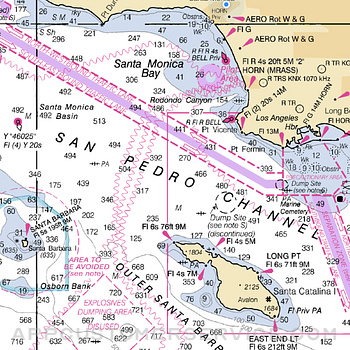
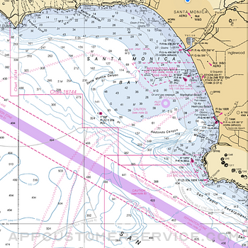
Electronic Navigational Charts (ENC) are vector data sets that support all types of marine navigation.
+ All charts are available to download for offline use
+ Chart format options include: NOAA, ECDIS
ENC charts display the following information:
+ Buoys, Beacons, Lights, Fog Signals, Radar
+ Natural and Man-Made Features
+ Services and Small Craft Facilities
+ Seabed, Obstructions, Pipelines
+ Depths, Currents
+ Port Features
+ Traffic Routes
+ Special areas
NOAA updates the ENCs for Notice to Mariners on a weekly basis. Timing of their availability is not guaranteed.
The ENC charts displayed in this app does NOT meet federal chart carriage regulations for regulated vessels.
Users should consult the Code of Federal Regulations for current federal chart carriage requirements.
-- NOAA WEATHER MAP OVERLAYS --
+ Weather Radar
+ Sea Surface Temperature
+ Significant Wave Height
+ Wind Speed & Direction
+ 12-Hour Rain Probability
+ Lightning Strike Density
+ Air Temperature
If you have any questions, please email [email protected]
Nautical Charts & Maps App Comments & Reviews
Nautical Charts & Maps Positive Reviews
Buy this app. Totally worth itThis app is great and hopefully marks the beginning of the end of the 25 year chokehold Garmin and Navionics have held over the boating world. Every American has contributed to the costs of NOAA putting together map databases. And for years the big companies fought to keep the raw data out of the hands of the public. So now it is finally available but predictively difficult to manage downloading and using the RASTER maps. This program does the hard work for you so now you can use all of the NOAA maps for free, forever, for only the cost of this program. It still lacks the ease and functionality of the big players but the app will get better and better as more boaters use it. Really fun for loookingbst digital charts of far away waters without paying extra for more charts. Have fun..Version: 1.1.4
Get it NOW!If you’re on the fence, jump off and DL this app. It’s better than the description implies. If you have a question about it, email the developer. I did, and got a response within an hour. The app is easily the best $$ you’ll spend today. You will only have to spend it once, no subscription for updates like similar apps. I got this as a backup for my onboard plotter and paper charts..Version: 1.0.8
Cheap and EasyNo longer a need to carry the fold ups in the boat. For the price of 2 maps, I’ve got the whole coast. Good use of technology. Really appreciate the ability to download the chart for use outside of cell phone range. Good for weekenders like me who can’t flip the $10k for a name brand monitor assembly. Plus - no ads getting in the way of the data. :-) Developer is responsive to inquiries..Version: 1.1.4
SimpleSimple chart program. Puts you on a Noaa chart. Lacks tools were accustomed to. Great value though. I’m hoping the developer will add a few tools. I’d gladly pay more if they’d add marks routing and a caliper tool. Keep it simple though. I payed 50 bucks for the original Navionics. Was really happy to do so. Now that they’ve gotten greedy and made it a ridiculous subscription I’m out. This app and its potential are a breath of fresh air..Version: 1.6
Beautiful App, but…This App provides great charts, however we live in the state of Washington near Canada which also has beautiful waterways that we love to explore, the provided charts Do Not include these needed Canadian waters charts. I’ll be glad to update the star rating to 5 stars if you’ll provide charts for the waterways between Washington and Alaska (the Canadian coastal waters). You have a really good thing going, please make it Great by adding the West Coast Canadian waterway charts!.Version: 1.6
Superb and CheapThis app makes the best case yet for electronic media satisfying chart carriage requirements. It’s economical, runs in off-line mode and is updated as frequently as NOAA charts are released. The only conceivable additions for me would be an ability to to place markers and something like the Navionics dividers applet for measuring point-to-point distances. But its pretty good as-is. And for the price.....Version: 1.1.4
Pretty good for what it isWas jet skiing in some costal waterways while on vacation and wanted a way to see the navigation charts with gps over lay for periodic location and depth checks. Did well. The one feature that would be nice is to have a find location button to make finding your location when opening the app easier. Otherwise get the intended job done well for a reasonable price..Version: 1.1.4
Very cool app!If you have phone service, you have a chart plotter. I have been using it to plan a return trip to the Pacific Northwest. I like that you can zoom in for fine details. The weather overlays are good for the San Francisco Bay if you want to see what the wind is doing and it is an easy-to-use program unlike some others..Version: 1.0.4
This Ap Rocks!Just started using this ap on my IPhone & really like it. Yep, I have GPS chart plotter On the boat but this works it’s just kind of a back up, and today I pulled it out or hiking and island and I had my exact position. Looking at the marina, and has this within 10 feet of the exact position of the boat. Good work!.Version: 1.0.4
Well doneI dig this app. It has yet to crash on me. I use it to periodically check my position while sailing and to research where to go next. It would be nice if it had a speed and course indicator, but I still give it 5 stars..Version: 1.1.9
Great App, great supportNice that you can download charts to use as backup to GPS plotter. I navigate the inside pass between WA and AK, so I have a the security of offline viewing of NOAA charts that I am familiar and comfortable with. Excellent support, developer emails promptly when I had questions. Nice to know someone gives a hoot for customer experience and service, thanks Will..Version: 1.1.4
Fantastic!Used this app for the first time to enter Vashon Island WA’s Quartermaster Harbor (look it up) at low tide on a no moon, pitch black night. There is no way we would have made it without this app. The marine supply store can keep their $700 gps charting units. I’m good!!.Version: 1.1.4
Great so farIt is handy for planning, needs a key/legend to identify the obstructions and markers etc. I like how after the maps are downloaded it easily transition from area to area. Would recommend it for an additional navigational aid..Version: 1.5
Maps no longer available?After response from supportI was able to download the RNC maps that have not yet been discontinued. Thank you!.Version: 1.1.15
Simple and all you needNo subscription. Detailed map. See yourself on it. Offline maps too. What else do you need. Get it..Version: 1.1.12
Well Designed AppThe app does a great job of stitching together the charts as you pan and zoom. Offline mode is essential when you’re offshore. Nice additional features like wind and waves..Version: 1.1.4
Excellent content and value for boaters.Tons of content and ability to download for use offline. Overlay of weather conditions. Thanks..Version: 1.1.9
Happy to have itMakes things easy.Version: 1.1.15
Great maps. Needs to be able to mark location and track routes.Love the maps and the offline mode. But lacks ability to drop a pin or record my route..Version: 1.1.9
Rockfish Conservation Area overlayThis is a great app. It has the best charts out there. The developer recently added an overlay with the west coast non trawl rockfish conservation area. He tells me there’s more to come..Version: 1.1.1
Great for the priceAt first I thought didn’t include inshore NC but you have to zoom. Can be slow to load sometimes, but overall pleased at this price..Version: 1.1.10
Do not waste your moneyI was looking for an app that gave me information on North American lakes. Thinking NOAA was the best of the best, I download the app and wasted money once AGAIN. COMPLETE WAIST OF MONEY..Version: 1.1.4
Great appVery handy and helpful on and off the boat. So far it’s perfect for my use when looking for structure for fishing👍.Version: 1.0.4
Great!!This app is very simple and straightforward and the price is right. I use it for planning fishing trips..Version: 1.1.11
The BEST Nautical Chart AppGreat nautical charts. Loads very fast, especially after the update. Love this company; they are very responsive to my messages..Version: 1.0.4
Simple but effectiveThis is a simple chart display program. No frills. Best that I have seen for changing scale.Version: 1.0.5
UnsatisfiedDownloaded the app and southern Bahamas is not available and crashes on iPhone on opening!.Version: 1.1.9
Good basic toolNot to be used for navigation but a helpful tool nonetheless.Version: 1.0.6
Tutorial?So far so great. So much to learn and info to learn. Is there a tutorial video?.Version: 1.1.9
Just what I was looking forNice clean marine navigation app, great support from developer.Version: 1.0.8
It’s good but…It’s good but for some reason you can’t download most maps They have a very small selection for offline use NOAA has them all for free I was just trying to find something to display but this isn’t it Anyways if in service it does seem like it uses raster well.Version: 1.1.12
Not the program I was looking forI was looking for a program for inland lakes Don.Version: 1.0.8
Useful KnowledgeVery useful and great idea for the sailor in all of us or sailor to be vital information.Version: 1.0.4
Question?Fine looking map, are charts available for N.E. Oklahoma?.Version: 1.7
Free International Money Transfer 💸Enjoy high maximum transfers into more than 20 currencies while saving up to 90% over local banks! The cheap, fast way to send money abroad. Free transfer up to 500 USD!Version: 1.11
What do you think Nautical Charts & Maps ios app? Can you share your thoughts and app experiences with other peoples?
Please wait! Facebook comments loading...


